Luxborough: Difference between revisions
Created page with "{{Infobox town |name=Luxborough |county=Somerset |picture=River Washford, Pooltown.jpg |picture caption=The bridge on the Washford River in Luxborough |os grid ref=SS976379 |l..." |
m ioe -> nhle, replaced: {{IoE|265357 → {{NHLE|1345725, {{IoE|265410 → {{NHLE|1345752 |
||
| Line 22: | Line 22: | ||
==Parish church== | ==Parish church== | ||
The Church of St Mary dates from the Norman period. It has a later tower and in the 19th century it was extended. It is a Grade II listed building<ref>{{ | The Church of St Mary dates from the Norman period. It has a later tower and in the 19th century it was extended. It is a Grade II listed building<ref>{{NHLE|1345725|Church of St Mary}}</ref> A new window was added in 2002. | ||
==History== | ==History== | ||
About 100 years ago, iron ore was mined around Luxborough.<ref>{{cite web | title=Exmoor Iron: a historical perspective. | work=Notes for the Archaeology Dept. Seminar, Exeter, 21 November 2002. | url=http://www.people.ex.ac.uk/pfclaugh/mhinf/ex_iron.lwp | accessdate=17 November 2006}}</ref> It was taken by train down the West Somerset Mineral Railway's incline to [[Watchet]], beside the [[Bristol Channel]] and shipped to [[Newport, Monmouthshire]]. This industry has left remains in several buildings, including stations, such as Luxborough Road railway station. | About 100 years ago, iron ore was mined around Luxborough.<ref>{{cite web | title=Exmoor Iron: a historical perspective. | work=Notes for the Archaeology Dept. Seminar, Exeter, 21 November 2002. | url=http://www.people.ex.ac.uk/pfclaugh/mhinf/ex_iron.lwp | accessdate=17 November 2006}}</ref> It was taken by train down the West Somerset Mineral Railway's incline to [[Watchet]], beside the [[Bristol Channel]] and shipped to [[Newport, Monmouthshire]]. This industry has left remains in several buildings, including stations, such as Luxborough Road railway station. | ||
Luxborough has a new village hall, built in a few years ago, and because there is no mobile phone signal in the village, it still has its old telephone box.<ref>{{ | Luxborough has a new village hall, built in a few years ago, and because there is no mobile phone signal in the village, it still has its old telephone box.<ref>{{NHLE|1345752|K6 telephone kiosk, Luxborough}}</ref> | ||
The village school was closed in 1971 (village children now attend Dunster School). In the 19th century though the school was reported to have 200 pupils from the village and the iron mines in the [[Brendon Hills]]. | The village school was closed in 1971 (village children now attend Dunster School). In the 19th century though the school was reported to have 200 pupils from the village and the iron mines in the [[Brendon Hills]]. | ||
Latest revision as of 08:27, 19 September 2019
| Luxborough | |
| Somerset | |
|---|---|
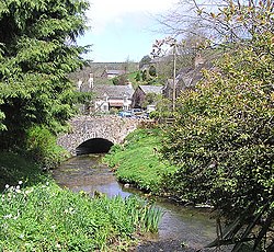
 The bridge on the Washford River in Luxborough | |
| Location | |
| Grid reference: | SS976379 |
| Location: | 51°7’54"N, 3°27’50"W |
| Data | |
| Population: | 237 (2011) |
| Post town: | Watchet |
| Postcode: | TA23 |
| Dialling code: | 01984 |
| Local Government | |
| Council: | Somerset West and Taunton |
| Parliamentary constituency: |
Bridgwater & W. Somerset |
Luxborough is a small village six miles south of Dunster in Somerset, amongst the Brendon Hills (and within the Exmoor National Park. It is divided into the hamlets of Churchtown, Kingsbridge and Pooltown, each within a mile of each other. It is all within the Carhampton Hundred of the county.
The name 'Luxborough' is found recorded as Lolochesberie in the Domesday Book of 1086, and means 'Luluc's stronghold' or perhaps 'Lulluc's hill', after and otherwise unknown landowner of ancient days.[1][2]
In 2011, the population of the parish was recorded as just 237.
Parish church
The Church of St Mary dates from the Norman period. It has a later tower and in the 19th century it was extended. It is a Grade II listed building[3] A new window was added in 2002.
History
About 100 years ago, iron ore was mined around Luxborough.[4] It was taken by train down the West Somerset Mineral Railway's incline to Watchet, beside the Bristol Channel and shipped to Newport, Monmouthshire. This industry has left remains in several buildings, including stations, such as Luxborough Road railway station.
Luxborough has a new village hall, built in a few years ago, and because there is no mobile phone signal in the village, it still has its old telephone box.[5]
The village school was closed in 1971 (village children now attend Dunster School). In the 19th century though the school was reported to have 200 pupils from the village and the iron mines in the Brendon Hills.
About the village
The Washford River rises close to the village and flows through the Kingsbridge valley, and Pooltown takes its name from the large number of pools on the river there. The Washford River is joined by one of its tributaries, which flows in the Churchtown valley, starting in the wooded combe called 'Throat'.
The village is both on the route of the Coleridge Way and Samaritans Way South West and is located within the Exmoor National Park.
Outside links
| ("Wikimedia Commons" has material about Luxborough) |
References
- ↑ Mills, A.D. (1998). English Place-Names. Oxford University Press. ISBN 0-19-280074-4.
- ↑ "Luxborough". Everything Exmoor. http://www.everythingexmoor.org.uk/_L/Luxborough.php. Retrieved 17 November 2006.
- ↑ National Heritage List 1345725: Church of St Mary
- ↑ "Exmoor Iron: a historical perspective.". Notes for the Archaeology Dept. Seminar, Exeter, 21 November 2002.. http://www.people.ex.ac.uk/pfclaugh/mhinf/ex_iron.lwp. Retrieved 17 November 2006.
- ↑ National Heritage List 1345752: K6 telephone kiosk, Luxborough
