Difference between revisions of "Llanarmon Mynydd Mawr"
(Created page with "{{Infobox town |county=Denbigh |picture=The chapel in Llanarmon Mynydd Mawr - geograph.org.uk - 1050249.jpg |picture caption=St Garmon's church in Llanarmon Mynydd Mawr. |post...") |
|||
| Line 9: | Line 9: | ||
|longitude=-3.285388 | |longitude=-3.285388 | ||
}} | }} | ||
| − | '''Llanarmon Mynydd Mawr''', occasionally referred to as Llanarmon Fach, is an isolated rural parish in the [[ | + | '''Llanarmon Mynydd Mawr''', occasionally referred to as Llanarmon Fach, is an isolated rural parish in the [[Chirk Hundred]] of [[Denbighshire]]. It has a population of 40.<ref name=llanfylin>[http://www.mathrafal.org/parishes/mynyddmawr.htm St Garmon's Church, Llanarmon Mynydd Mawr]</ref> |
The scattered settlement lies on the south-facing slopes of the [[Berwyn Mountains]] in the high upper part of the [[River Tanat|Tanat]] Valley, at around 950 feet above sea level. Its name translates roughly as "St Garmon's church [on the] Great Mountain", distinguishing it from the village of [[Llanarmon Dyffryn Ceiriog]], five miles away in the [[Ceiriog Valley]]. | The scattered settlement lies on the south-facing slopes of the [[Berwyn Mountains]] in the high upper part of the [[River Tanat|Tanat]] Valley, at around 950 feet above sea level. Its name translates roughly as "St Garmon's church [on the] Great Mountain", distinguishing it from the village of [[Llanarmon Dyffryn Ceiriog]], five miles away in the [[Ceiriog Valley]]. | ||
Revision as of 20:51, 4 March 2019
| Llanarmon Mynydd Mawr | |
| Denbighshire | |
|---|---|
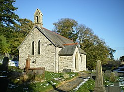
 St Garmon's church in Llanarmon Mynydd Mawr. | |
| Location | |
| Location: | 52°50’31"N, 3°17’7"W |
| Data | |
| Post town: | Oswestry |
| Postcode: | SY10 |
| Local Government | |
| Council: | Powys |
Llanarmon Mynydd Mawr, occasionally referred to as Llanarmon Fach, is an isolated rural parish in the Chirk Hundred of Denbighshire. It has a population of 40.[1]
The scattered settlement lies on the south-facing slopes of the Berwyn Mountains in the high upper part of the Tanat Valley, at around 950 feet above sea level. Its name translates roughly as "St Garmon's church [on the] Great Mountain", distinguishing it from the village of Llanarmon Dyffryn Ceiriog, five miles away in the Ceiriog Valley.
History
The church of St Garmon (St Germanus) is thought to be of early-mediæval origin; it was 'restored' in 1886 to designs by W. H. Spaull of Oswestry.[1] The area was historically a township of the parish of Llanrhaeadr-ym-Mochnant but eventually became a separate parish.[2] It forms part of the community of Llanrhaeadr-ym-Mochnant for civil administration purposes.
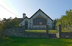
The area of the parish is today largely mountain pasture. As with many such communities, its population has fallen over the years: in 1833 it had 164 inhabitants.[3] There are a number of rare late-medieval cruck-framed buildings.[4] There is also a Calvinistic Methodist chapel, Hermon, rebuilt in 1906 in a "curious" Art Nouveau-influenced style.[5]
The academic Griffith Hartwell Jones was the son of a rector of Llanarmon Mynydd Mawr, the Rev. Edward Jones. A previous incumbent (1578–95) was William Morgan, Bible translator and later Bishop of Llandaff.
References
- ↑ 1.0 1.1 St Garmon's Church, Llanarmon Mynydd Mawr
- ↑ Tanat Valley, Clwyd-Powys Archaeological Trust
- ↑ Llanarmon Mynydd Mawr, GENUKI
- ↑ Tanat Valley Historic Landscape Characterisation, Clwyd-Powys Archaeological Trust
- ↑ Jones, A. Welsh chapels, National Museum of Wales, 1996, p.129
