Llanengan: Difference between revisions
Jump to navigation
Jump to search
Created page with '{{Infobox town |name=Llanengan |county=Caernarfonshire |picture=View north towards Llanengan - geograph.org.uk - 638286.jpg |picture caption=Llanegan |os grid ref=SH2926 |latitud…' |
mNo edit summary |
||
| Line 21: | Line 21: | ||
The popular seaside resort village of [[Abersoch]] falls within the parish, though Abersoch itself is the larger village. | The popular seaside resort village of [[Abersoch]] falls within the parish, though Abersoch itself is the larger village. | ||
Lead was formerly obtained from a lead mine just outside the village. A chimney can be seen on the left from the road to Porth Neigwl, which means "Hell's Mouth | Lead was formerly obtained from a lead mine just outside the village. A chimney can be seen on the left from the road to Porth Neigwl, which means "Hell's Mouth". The chimney marks the entrance to the former lead workings.<ref>Atlas of Caernarfonshire; ed. T.M. Basset, B.L. Davies; Gwynedd Rural Council, Caernarfon 1976</ref> | ||
==Outside links== | ==Outside links== | ||
Latest revision as of 13:26, 6 February 2012
| Llanengan | |
| Caernarfonshire | |
|---|---|
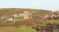
 Llanegan | |
| Location | |
| Grid reference: | SH2926 |
| Location: | 52°48’32"N, 4°31’52"W |
| Data | |
| Population: | 2,024 (2001) |
| Post town: | Pwllheli |
| Postcode: | LL53 |
| Dialling code: | 01758 |
| Local Government | |
| Council: | Gwynedd |
| Parliamentary constituency: |
Caernarfon |
Llanengan is a small village in Caernarfonshire just over a mile southwest of Abersoch on Llŷn. It had a population of 2,024 in 2001.
In its centre is the parish church of St Einion, one of the oldest churches in the Llŷn peninsula.
The popular seaside resort village of Abersoch falls within the parish, though Abersoch itself is the larger village.
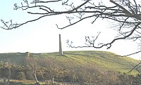
Lead was formerly obtained from a lead mine just outside the village. A chimney can be seen on the left from the road to Porth Neigwl, which means "Hell's Mouth". The chimney marks the entrance to the former lead workings.[1]
Outside links
References

- ↑ Atlas of Caernarfonshire; ed. T.M. Basset, B.L. Davies; Gwynedd Rural Council, Caernarfon 1976