Strath of Kildonan: Difference between revisions
Created page with "right|thumb|300px|The Strath of Kildonan, Sutherland '''Strath of Kildonan''', also known as '''Strath Ullie''', ({..." |
No edit summary |
||
| Line 1: | Line 1: | ||
{{county|Sutherland}} | |||
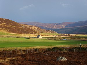
[[File:Strath of Kildonan - geograph.org.uk - 1192901.jpg|right|thumb|300px|The Strath of Kildonan, Sutherland]] | [[File:Strath of Kildonan - geograph.org.uk - 1192901.jpg|right|thumb|300px|The Strath of Kildonan, Sutherland]] | ||
'''Strath of Kildonan''' | The '''Strath of Kildonan''' is a valley in the north-east of [[Sutherland]]. It extends in a north-westerly direction from [[Helmsdale]] up into the hills towards [[Kinbrace]]. It is also known as '''Strath Ullie''', from the Gaelic ''Srath Ilidh''. | ||
The [[River Helmsdale]] (also known as River Ullie) flows down the strath, and into the sea at Helmsdale. | The [[River Helmsdale]] (also known as River Ullie) flows down the strath, and into the sea at Helmsdale. | ||
Latest revision as of 12:08, 9 December 2018

The Strath of Kildonan is a valley in the north-east of Sutherland. It extends in a north-westerly direction from Helmsdale up into the hills towards Kinbrace. It is also known as Strath Ullie, from the Gaelic Srath Ilidh.
The River Helmsdale (also known as River Ullie) flows down the strath, and into the sea at Helmsdale.
The A897 road runs along the strath, as does the Far North Line, with Kildonan railway station halfway along.
In 1869 gold was found in the valley, and was exploited by local crofters and outside prospectors until the enterprise became unprofitable. A following depression in the local economy caused crofters to resume gold digging, which by 1886 brought them into conflict with the Sutherland Estates.
The Parish of Kildonan
The Parish of Kildonan lies within the Strath of Kildonan. There is no village of Kildonan as such by numerous scattered farmsteads. The biggest collection of dwellings are found at Kildonan Lodge and Kildonan Farm a little further down the valley.
Outside links
- Location map: 58°10’22"N, 3°51’24"W
- Streetmap: NC908219