Cnicht: Difference between revisions
Created page with '{{Infobox hill |name=Cnicht |county=Merionethshire |range=Moelwynion |picture=Cnicht from west.jpg |picture caption=Cnicht from the south-west |os grid ref=SH645466 |height=2,260…' |
mNo edit summary |
||
| Line 6: | Line 6: | ||
|picture caption=Cnicht from the south-west | |picture caption=Cnicht from the south-west | ||
|os grid ref=SH645466 | |os grid ref=SH645466 | ||
|latitude=52.999529 | |||
|longitude=-4.020544 | |||
|height=2,260 feet | |height=2,260 feet | ||
}} | }} | ||
'''Cnicht''' is a mountain among the [[Moelwynion]] in [[Merionethshire]]. | '''Cnicht''' is a mountain among the [[Moelwynion]] in [[Merionethshire]]. | ||
The appearance of Cnicht when viewed from the | The appearance of Cnicht when viewed from the south-west, from the direction of [[Porthmadog]], has earned it the sobriquet the "Matterhorn of Wales". In reality Cnicht is a long ridge and, at 2,260 feet it is the 5th highest peak in the [[Moelwynion]] range. It can be easily ascended from [[Croesor]], the village at its foot, or, with more difficulty, from [[Nant Gwynant]] to the north-west. | ||
Although a distinctive mountain in its own right, it has been excluded from the Nuttall list as lacking enough prominence in terms of elevation to separate it from [[Allt-fawr]] in spite of over 361 feet of re-ascent and a distance of more than 2½ miles. | Although a distinctive mountain in its own right, it has been excluded from the Nuttall list as lacking enough prominence in terms of elevation to separate it from [[Allt-fawr]], in spite of over 361 feet of re-ascent and a distance of more than 2½ miles. | ||
The mountain gets its name from the Old English word ''Cniht'', meaning "knight" (in which, in Welsh, the ''c'' is pronounced). It is said that the shape of the mountain bears a similarity to a knight's helmet. | The mountain gets its name from the Old English word ''Cniht'', meaning "knight" (in which, in Welsh, the ''c'' is pronounced). It is said that the shape of the mountain bears a similarity to a knight's helmet. | ||
Latest revision as of 15:51, 11 September 2018
| Cnicht | |||
| Merionethshire | |||
|---|---|---|---|
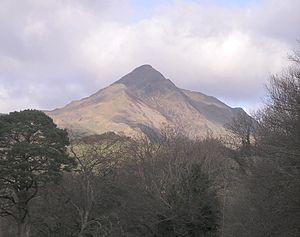
 Cnicht from the south-west | |||
| Range: | Moelwynion | ||
| Summit: | 2,260 feet SH645466 52°59’58"N, 4°1’14"W | ||
Cnicht is a mountain among the Moelwynion in Merionethshire.
The appearance of Cnicht when viewed from the south-west, from the direction of Porthmadog, has earned it the sobriquet the "Matterhorn of Wales". In reality Cnicht is a long ridge and, at 2,260 feet it is the 5th highest peak in the Moelwynion range. It can be easily ascended from Croesor, the village at its foot, or, with more difficulty, from Nant Gwynant to the north-west.
Although a distinctive mountain in its own right, it has been excluded from the Nuttall list as lacking enough prominence in terms of elevation to separate it from Allt-fawr, in spite of over 361 feet of re-ascent and a distance of more than 2½ miles.
The mountain gets its name from the Old English word Cniht, meaning "knight" (in which, in Welsh, the c is pronounced). It is said that the shape of the mountain bears a similarity to a knight's helmet.
Cnicht appears fictionalised as the Saeth in Patrick O'Brian's 1952 novel Three Bear Witness, which is set in a fictionalised version of Cwm Croesor.[1] O'Brian and his wife lived in the valley between 1946 and 1949.
Outside links
References
- ↑ Tolstoy, Nikolai (2005). Patrick O'Brian:The making of the novelist. London: Arrow. pp. 337–339. ISBN 0-09-941584-4.