Loch Arklet: Difference between revisions
Jump to navigation
Jump to search
Created page with "right|thumb|300px|The Arrochar Alps across Loch Arklet {{county|Stirlingshire}} '''Loch Arklet'''..." |
No edit summary |
||
| Line 1: | Line 1: | ||
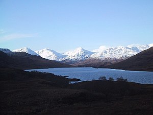
[[File:The Arrocher Hills across Loch Arklet - geograph.org.uk - 925118.jpg|right|thumb|300px|The Arrochar Alps across Loch Arklet]] | [[File:The Arrocher Hills across Loch Arklet - geograph.org.uk - 925118.jpg|right|thumb|300px|The Arrochar Alps across Loch Arklet]] | ||
{{county|Stirlingshire}} | {{county|Stirlingshire}} | ||
'''Loch Arklet''' is a pretty loch in [[Stirlingshire]], in the very north-western corner of the county, stretching east to west between [[Loch Katrine]] and [[Loch Lomond]], with just | '''Loch Arklet''' is a pretty loch in [[Stirlingshire]], in the very north-western corner of the county, stretching east to west between [[Loch Katrine]] and [[Loch Lomond]], with just narrow gaps separating it from those two lochs. | ||
The western end of the loch is dammed, and from below the dam the Arklet Water drains it and flows down to Loch Lomond. The top end of the loch, its eastern shore, marks the border with [[Perthshire]] to the east. | The western end of the loch is dammed, and from below the dam the Arklet Water drains it and flows down to Loch Lomond. The top end of the loch, its eastern shore, marks the border with [[Perthshire]] to the east. | ||
Latest revision as of 07:49, 6 April 2018

Loch Arklet is a pretty loch in Stirlingshire, in the very north-western corner of the county, stretching east to west between Loch Katrine and Loch Lomond, with just narrow gaps separating it from those two lochs.
The western end of the loch is dammed, and from below the dam the Arklet Water drains it and flows down to Loch Lomond. The top end of the loch, its eastern shore, marks the border with Perthshire to the east.
There are no villages beside the loch but a scattered hamlet, Corriearklet, on the minor road running along its north shore. The loch is within the Loch Lomond and the Trossachs National Park.
Location
- Location map: 56°14’45"N, 4°37’18"W
- Streetmap: NN376090