Fumarole Bay: Difference between revisions
Created page with "{{territory|British Antarctic Territory}} '''Fumarole Bay''' is a bay on the west side of Port Foster, the major harbour of Deception Island, in the South Shetland I..." |
No edit summary |
||
| Line 1: | Line 1: | ||
[[File:South Shetland-2016-Deception Island–Deception Station (Argentine base).jpg|right|thumb|300px|''Decepción'' station on Fumarole Bay]] | |||
{{territory|British Antarctic Territory}} | {{territory|British Antarctic Territory}} | ||
'''Fumarole Bay''' is a bay on the west side of [[Port Foster]], the major harbour of [[Deception Island]], in the [[South Shetland Islands]]; part of the [[British Antarctic Territory]]. | '''Fumarole Bay''' is a bay on the west side of [[Port Foster]], the major harbour of [[Deception Island]], in the [[South Shetland Islands]]; part of the [[British Antarctic Territory]]. | ||
| Line 5: | Line 6: | ||
==Survey and naming== | ==Survey and naming== | ||
[[File:Deception Island Map.svg|right|thumb|250px|Map of Deception Island]] | |||
The Argentine Antarctic Expedition of 1942-3 named the bay ''Bahai 1° de Mayo'' or ''Bahía Primero de Mayo'' after the expedition ship ''1° de Mayo'', which sank near Monte Hermoso off the coast of Argentina on 5 February 1944. An Argentinian station, called "1° de Mayo", was established on the bay on 20 November 1947; later called "Destacamento Naval Decepción". | The Argentine Antarctic Expedition of 1942-3 named the bay ''Bahai 1° de Mayo'' or ''Bahía Primero de Mayo'' after the expedition ship ''1° de Mayo'', which sank near Monte Hermoso off the coast of Argentina on 5 February 1944. An Argentinian station, called "1° de Mayo", was established on the bay on 20 November 1947; later called "Destacamento Naval Decepción". | ||
Latest revision as of 12:58, 2 April 2018

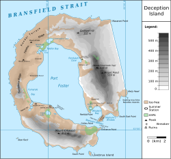
Fumarole Bay is a bay on the west side of Port Foster, the major harbour of Deception Island, in the South Shetland Islands; part of the British Antarctic Territory.
The island is an unquiet volcano, Port Foster being its breached and flooded crater, and in Fumerole Bay is the island's most active fumarole, or volcanic vent, hence its name.
Survey and naming

The Argentine Antarctic Expedition of 1942-3 named the bay Bahai 1° de Mayo or Bahía Primero de Mayo after the expedition ship 1° de Mayo, which sank near Monte Hermoso off the coast of Argentina on 5 February 1944. An Argentinian station, called "1° de Mayo", was established on the bay on 20 November 1947; later called "Destacamento Naval Decepción".
The Falkland Islands Dependencies Survey carried out a full survey in 1953-54. Aerial photography was carried out by the Falkland Islands and Dependencies Aerial Survey Expedition of 1956-57. After this, the bay was named 'Fumarole Bay' because the most active fumarole on the island is situated here.
The Argentine station was closed to permanent occupation following the volcanic eruption on the island on 4 December 1967.
Location map
- Location map: 62°57’58"S, 60°42’0"W
References
- Gazetteer and Map of The British Antarctic Territory: Fumarole Bay