Carn Glas-choire: Difference between revisions
Jump to navigation
Jump to search
Created page with '{{Infobox hill |name=Carn Glas-choire |county 1=Inverness-shire |county 2=Nairnshire |range=Cairngorms |picture=Carn Glas-choire Summit - geograph.org.uk - 865351.jpg |picture ca…' |
No edit summary |
||
| Line 3: | Line 3: | ||
|county 1=Inverness-shire | |county 1=Inverness-shire | ||
|county 2=Nairnshire | |county 2=Nairnshire | ||
|county 3=Moray | |||
|range=Cairngorms | |range=Cairngorms | ||
|picture=Carn Glas-choire Summit - geograph.org.uk - 865351.jpg | |picture=Carn Glas-choire Summit - geograph.org.uk - 865351.jpg | ||
| Line 8: | Line 9: | ||
|height=2,162 feet | |height=2,162 feet | ||
|os grid ref=NH891291 | |os grid ref=NH891291 | ||
|latitude=57.3388 | |||
|longitude=-3.8441 | |||
}} | }} | ||
'''Carn Glas-choire''' is a mountain on the border of [[Nairnshire]] | '''Carn Glas-choire''' is a mountain on the border of [[Nairnshire]], [[Inverness-shire]] and [[Morayshire]] detached. It is at the very southernmost point of Nairnshire and is its highest point too, the [[county top]]. | ||
Not a dramatic peak, Carn Glas-choire's summit is the highest point of the huge plateau spread out | Not a dramatic peak, Carn Glas-choire's summit is the highest point of the huge plateau spread out north-east of the Slochd Pass, a place of bleak, wind-ravaged moorland. | ||
A little below the summit is a sizeable lochan named Loch Bràigh Bhruthiach, and from here and many burns on the mountainside run waters which swell the [[River Findhorn]] to the west. Waters run south from the mountain to [[Carrbridge]] and [[Duthil]] to swell the [[River Dulnain]] and thence the [[River Spey|Spey]]. | A little below the summit is a sizeable lochan named Loch Bràigh Bhruthiach, and from here and many burns on the mountainside run waters which swell the [[River Findhorn]] to the west. Waters run south from the mountain to [[Carrbridge]] and [[Duthil]] to swell the [[River Dulnain]] and thence the [[River Spey|Spey]]. | ||
Latest revision as of 11:03, 1 February 2018
| Carn Glas-choire | |||
| Inverness-shire, Nairnshire, Morayshire | |||
|---|---|---|---|
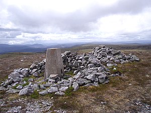
 Carn Glas-choire summit | |||
| Range: | Cairngorms | ||
| Summit: | 2,162 feet NH891291 57°20’20"N, 3°50’39"W | ||
Carn Glas-choire is a mountain on the border of Nairnshire, Inverness-shire and Morayshire detached. It is at the very southernmost point of Nairnshire and is its highest point too, the county top.
Not a dramatic peak, Carn Glas-choire's summit is the highest point of the huge plateau spread out north-east of the Slochd Pass, a place of bleak, wind-ravaged moorland.
A little below the summit is a sizeable lochan named Loch Bràigh Bhruthiach, and from here and many burns on the mountainside run waters which swell the River Findhorn to the west. Waters run south from the mountain to Carrbridge and Duthil to swell the River Dulnain and thence the Spey.
