Lower Ballinderry: Difference between revisions
Created page with '{{Infobox town |name=Lower Ballinderry |county=Antrim |picture= |picture caption= |os grid ref=J1267 |LG district=Lisburn }} '''Lower Ballinderry''' is a village in [[County Antr…' |
No edit summary |
||
| Line 2: | Line 2: | ||
|name=Lower Ballinderry | |name=Lower Ballinderry | ||
|county=Antrim | |county=Antrim | ||
|picture= | |picture=Ballinderry Moravian Church - geograph.org.uk - 58878.jpg | ||
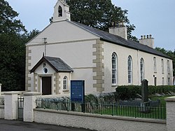
|picture caption= | |picture caption=Ballinderry Moravian Church | ||
|os grid ref= | |os grid ref=J128676 | ||
|LG district=Lisburn | |latitude=54.544083 | ||
|longitude=-6.257033 | |||
|postcode=BT28 | |||
|post town=Lisburn | |||
|population= | |||
|census year= | |||
|LG district=Lisburn and Castlereagh | |||
|constituency= | |||
|website= | |||
}} | }} | ||
'''Lower Ballinderry''' is a village in [[County Antrim]]. | '''Lower Ballinderry''' is a small village to the west of [[Upper Ballinderry]] in [[County Antrim]], all within the townland of [[Ballinderry, County Antrim|Ballinderry]] and the Barony of [[Massereene Upper]]. | ||
{{ | The village sits a short distance to the southeast of Portmore Lough (otherwise known as Lough Beg) and beyond it the vast expanse of [[Lough Neagh]]. It is seven and a half miles to the west of [[Lisburn]]. In the 2001 it had a population of 441. | ||
The village sits at a crossroads that linked the mediæval church site of [[Aghagallon]] (Ballinderry Old Graveyard), and later to Portmore Castle, established at the Plantation of Ulster. | |||
The village has at its core Ballinderry Moravian Church (a listed building) which along with other listed structures forms a distinct core to the settlement around the crossroads. It has a pre-eminently 18th century character, visible in buildings, in form and layout, and in the lime tree plantings. | |||
==Churches== | |||
*Ballinderry Moravian Church | |||
==See also== | |||
*[[Upper Ballinderry]] | |||
==Outside links== | |||
{{commons}} | |||
*[http://www.lisburn.com/books/moravian/moravian1.html History of Ballinderry Moravian Church] | |||
==References== | |||
{{Reflist}} | |||
Latest revision as of 17:38, 18 November 2017
| Lower Ballinderry | |
| County Antrim | |
|---|---|
 Ballinderry Moravian Church | |
| Location | |
| Grid reference: | J128676 |
| Location: | 54°32’39"N, 6°15’25"W |
| Data | |
| Post town: | Lisburn |
| Postcode: | BT28 |
| Local Government | |
| Council: | Lisburn and Castlereagh |
Lower Ballinderry is a small village to the west of Upper Ballinderry in County Antrim, all within the townland of Ballinderry and the Barony of Massereene Upper.
The village sits a short distance to the southeast of Portmore Lough (otherwise known as Lough Beg) and beyond it the vast expanse of Lough Neagh. It is seven and a half miles to the west of Lisburn. In the 2001 it had a population of 441.
The village sits at a crossroads that linked the mediæval church site of Aghagallon (Ballinderry Old Graveyard), and later to Portmore Castle, established at the Plantation of Ulster.
The village has at its core Ballinderry Moravian Church (a listed building) which along with other listed structures forms a distinct core to the settlement around the crossroads. It has a pre-eminently 18th century character, visible in buildings, in form and layout, and in the lime tree plantings.
Churches
- Ballinderry Moravian Church
See also
Outside links
| ("Wikimedia Commons" has material about Lower Ballinderry) |
