Ben Lomond: Difference between revisions
mNo edit summary |
No edit summary |
||
| Line 8: | Line 8: | ||
|range= | |range= | ||
|os grid ref=NN367029 | |os grid ref=NN367029 | ||
|latitude=56.190631 | |||
|longitude=-4.633164 | |||
}} | }} | ||
'''Ben Lomond''' is a mountain in [[Stirlingshire]], within the [[Highlands]]. It rises on the eastern shore of [[Loch Lomond]] to a height of 3,196 feet; the most southerly of the [[Munro]]s. | '''Ben Lomond''' is a mountain in [[Stirlingshire]], within the [[Highlands]]. It rises on the eastern shore of [[Loch Lomond]] to a height of 3,196 feet; the most southerly of the [[Munro]]s. | ||
| Line 20: | Line 22: | ||
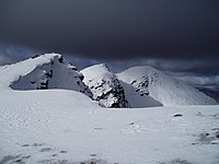
[[File:Summit Ridge of Ben Lomond - geograph.org.uk - 133982.jpg|right|thumb|200px|The summit ridge and northeast face, winter]] | [[File:Summit Ridge of Ben Lomond - geograph.org.uk - 133982.jpg|right|thumb|200px|The summit ridge and northeast face, winter]] | ||
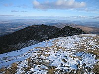
[[File:Ben Lomond Summit.jpg|right|thumb|200px|The summit]] | [[File:Ben Lomond Summit.jpg|right|thumb|200px|The summit]] | ||
The mountain comprises two parallel south- | The mountain comprises two parallel south-south-easterly ridges: the Sròn Aonaich ridge to the east and the Ptarmigan ridge to the west. North of the summit these ridges come together and lead to a 1,496-foot col with Cruin a' Bheinn. The summit is grassy and rocky and is marked by a trig point. | ||
Ben Lomond's geology is dominated by granite, mica schist, diorite, porphyry and quartzite. The mountain forms part of the watershed between eastward and westward draining waters. | Ben Lomond's geology is dominated by granite, mica schist, diorite, porphyry and quartzite. The mountain forms part of the watershed between eastward and westward draining waters. | ||
| Line 48: | Line 50: | ||
==Popular culture== | ==Popular culture== | ||
Ben Lomond's popularity | Ben Lomond's popularity has resulted in several namesakes in British colonies, in Australia, New Zealand, Trinidad and the United States. The mountain is mentioned in the popular folk song ''The Bonnie Banks o' Loch Lomond''. | ||
==Outside links== | ==Outside links== | ||
{{commons | {{commons}} | ||
*{{NT link}} | *{{NT link}} | ||
*Computer-generated virtual panorama from Ben Lomond [http://www.viewfinderpanoramas.org/panoramas/GRW/Lomond-N.gif North] [http://www.viewfinderpanoramas.org/panoramas/GRW/Lomond-S.gif South] [http://www.viewfinderpanoramas.org/panoramas.html Index] | *Computer-generated virtual panorama from Ben Lomond [http://www.viewfinderpanoramas.org/panoramas/GRW/Lomond-N.gif North] [http://www.viewfinderpanoramas.org/panoramas/GRW/Lomond-S.gif South] [http://www.viewfinderpanoramas.org/panoramas.html Index] | ||
Latest revision as of 10:30, 3 October 2017
| Ben Lomond | |
| Stirlingshire | |
|---|---|
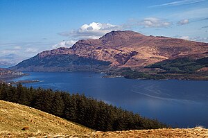
 Ben Lomond from across Loch Lomond | |
| Summit: | 3,196 feet NN367029 56°11’26"N, 4°37’59"W |
Ben Lomond is a mountain in Stirlingshire, within the Highlands. It rises on the eastern shore of Loch Lomond to a height of 3,196 feet; the most southerly of the Munros.
It is a solitary and distinctive mountain. Looking south from the Arrochar Alps, Ben Lomond appears to have a conical summit but there is a craggy corrie high on its steep, northern slopes.
The mountain's name comes from the Gaelic Beinn Laomainn, meaning "Beacon Mountain". It stands within the Ben Lomond National Memorial Park and the Loch Lomond and the Trossachs National Park, and is the property of the National Trust for Scotland.
Ben Lomond is one of the most popular climbs amongst the Munros, since it is relatively easy to reach from the cities and a relatively easy climb from Rowardennan. On a clear day from the higher grounds of Glasgow it is a visible, luring presence and likewise across the Central Lowlands, which may have led to it being named "Beacon Mountain". Ben Lomond summit can also be seen from Ben Nevis, the highest peak in the British Isles, over 70 miles away.
Geography and geology


The mountain comprises two parallel south-south-easterly ridges: the Sròn Aonaich ridge to the east and the Ptarmigan ridge to the west. North of the summit these ridges come together and lead to a 1,496-foot col with Cruin a' Bheinn. The summit is grassy and rocky and is marked by a trig point.
Ben Lomond's geology is dominated by granite, mica schist, diorite, porphyry and quartzite. The mountain forms part of the watershed between eastward and westward draining waters.
Ascents
The West Highland Way runs along the western base of the mountain, by the loch.
The usual route up Ben Lomond is by way of the 'tourist path', a broad and now heavily eroded path which is roughly paved in steeper sections. It is a relatively unchallenging path, created in view of to the mountain's popularity.[1][2] The Tourist Path climbs the gentle Sròn Aonaich ridge, before ascending a steeper section to the rocky summit ridge.
An alternative route follows the Ptarmigan Ridge to the summit along a steeper and rockier path. The Ptarmigan Path is the second most popular route.
A third route approaches from Gleann Dubh.[1]
Despite the comparative ease of the tourist route, Ben Lomond can present a significant challenge to inexperienced walkers, especially in poor weather conditions.[3] A dedicated Lomond Mountain Rescue Team has existed since 1967 to assist walkers and climbers on Ben Lomond other surrounding peaks.[4]
Birds and beasts
The higher regions of the mountain support an alpine tundra ecozone, hosting bird species including peregrine falcon, merlins, rock ptarmigan, red grouse and golden eagles.[5] A study by the British Trust for Ornithology found that Ben Lomond may host the most southerly breeding ptarmigan population in Scotland,[6] following the decline of these populations on Goatfell and the Arran mountains.
In addition to natural wildlife, the mountain area supports sheep farming activities. The National Trust for Scotland is tasked with maintaining a land management programme which sustains a balance of natural habitat conservation and the availability of land for grazing.[2]
Memorial Park and National Park
Since 1995,[2] the area around Ben Lomond, including the mountain summit, has been designated as a war memorial, called the Ben Lomond National Memorial Park. The park is dedicated to those who gave their lives in the First and Second World Wars and was created out of the former Rowardennan Estate with the support of the National Heritage Memorial Fund.[7]
The Memorial Park was officially opened on Armistice Day in 1997 and there was unveiled in the pristine wilderness a large granite sculpture.
At the time of its creation, management of the Memorial Park was entrusted to the National Trust for Scotland, the Forestry Commission and the Scottish Office.[7]
Popular culture
Ben Lomond's popularity has resulted in several namesakes in British colonies, in Australia, New Zealand, Trinidad and the United States. The mountain is mentioned in the popular folk song The Bonnie Banks o' Loch Lomond.
Outside links
| ("Wikimedia Commons" has material about Ben Lomond) |
- Ben Lomond
- Computer-generated virtual panorama from Ben Lomond North South Index
References
- ↑ 1.0 1.1 Robin Howie (30 February 2008). "Walk on the wild side: A climb up the tourist route of Ben Lomond". Media. The Scotsman. http://thescotsman.scotsman.com/scotsmanmagazine/Walk-on-the-wild-side.4432500.jp. Retrieved 2010-01-24.
- ↑ 2.0 2.1 2.2 "Ben Lomond". National Trust for Scotland. http://www.nts.org.uk/Property/11/. Retrieved 2010-01-24. Cite error: Invalid
<ref>tag; name "NTS" defined multiple times with different content - ↑ "Lost walkers spark police anger". BBC News. 14 December 2008. http://news.bbc.co.uk/1/hi/scotland/glasgow_and_west/7782289.stm. Retrieved 2010-01-24.
- ↑ "Lomond MRT". http://www.lomondmrt.org.uk/index.php. Retrieved 2010-01-24.
- ↑ "Loch Lomond and the Trossachs National Park". http://www.lochlomond-trossachs.org/learning/mountains-and-moorland/menu-id-304.html. Retrieved 2010-01-24.
- ↑ "Southerly ptarmigan decline fears". BBC News. 1 February 2009. http://news.bbc.co.uk/1/hi/scotland/north_east/7822989.stm. Retrieved 2010-01-24.
- ↑ 7.0 7.1 "Donald Dewar opens Ben Lomond National Memorial Park". The Scottish Government. 11 November 1997. http://www.scotland.gov.uk/News/Releases/1997/11/1bcd537f-eaff-469b-baaa-d239f0472582. Retrieved 2010-01-24.
| Munros in SMC Area SMC Section 1 - Loch Lomond to Loch Tay |
|---|
|
An Caisteal • Beinn a' Chleibh • Beinn a' Chroin • Beinn Bhuidhe • Beinn Chabhair • Beinn Dubhchraig • Beinn Ìme • Beinn Narnain • Beinn Tulaichean • Ben Chonzie • Ben Lomond • Ben Lui • Ben More • Ben Oss • Ben Vane • Ben Vorlich, Dunb. • Ben Vorlich, Perth. • Cruach Ardrain • Stob Binnein • Stuc a' Chroin |
