Mither Tap: Difference between revisions
Jump to navigation
Jump to search
Created page with '{{Infobox hill |name=Mither Tap |county=Aberdeenshire |range=Bennachie |picture=Mither Tap from the South - geograph.org.uk - 55769.jpg |picture caption=Mither Tap from the south…' |
No edit summary |
||
| Line 7: | Line 7: | ||
|height=1,732 feet | |height=1,732 feet | ||
|os grid ref=NJ662226 | |os grid ref=NJ662226 | ||
|latitude=57.292749 | |||
|longitude=-2.562439 | |||
}} | }} | ||
'''Mither Tap''' is the most prominent peak of [[Bennachie]] in [[Aberdeenshire]]. Its summit stands at 1,699 feet and gives good views of the county to the north and east. | '''Mither Tap''' is the most prominent peak of [[Bennachie]] in [[Aberdeenshire]]. Its summit stands at 1,699 feet and gives good views of the county to the north and east. | ||
| Line 12: | Line 14: | ||
The hill has an Iron Age fort on its summit. Unlike with many other hilltop forts in the area, there are no signs of vitrification in the stone. | The hill has an Iron Age fort on its summit. Unlike with many other hilltop forts in the area, there are no signs of vitrification in the stone. | ||
[[File:Mither_tap_view_north.jpg|View north from Mither Tap| | [[File:Mither_tap_view_north.jpg|View north from Mither Tap|thumb|left|200px|View north from the summit]] | ||
[[Category:Hill forts in Aberdeenshire]] | [[Category:Hill forts in Aberdeenshire]] | ||
Latest revision as of 08:40, 28 September 2017
| Mither Tap | |||
| Aberdeenshire | |||
|---|---|---|---|
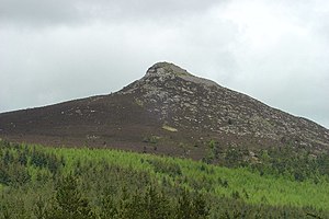
 Mither Tap from the south | |||
| Range: | Bennachie | ||
| Summit: | 1,732 feet NJ662226 57°17’34"N, 2°33’45"W | ||
Mither Tap is the most prominent peak of Bennachie in Aberdeenshire. Its summit stands at 1,699 feet and gives good views of the county to the north and east.
The hill has an Iron Age fort on its summit. Unlike with many other hilltop forts in the area, there are no signs of vitrification in the stone.
