Sunderland, Cumberland: Difference between revisions
Jump to navigation
Jump to search
Created page with "{{Infobox town |name=Sunderland |county=Cumberland |picture="C" class road at Sunderland - geograph.org.uk - 578279.jpg |picture caption=Sunderland |os grid ref=NY178354 |lati..." |
No edit summary |
||
| Line 15: | Line 15: | ||
|post town=Allerdale | |post town=Allerdale | ||
}} | }} | ||
'''Sunderland''' is a hamlet within the [[Lake District]] National Park, in the parish of [[Blindcrake]] in the [[Cumberland]]. | '''Sunderland''' is a hamlet within the [[Lake District]] National Park, in the parish of [[Blindcrake]] in the county of [[Cumberland]]. | ||
Nearby places include such towns as [[Cockermouth]], [[Keswick]], [[Bothel]] and [[Aspatria]]. The nearest railway station is at Aspatria. | Nearby places include such towns as [[Cockermouth]], [[Keswick]], [[Bothel]] and [[Aspatria]]. The nearest railway station is at Aspatria. | ||
Latest revision as of 22:35, 10 August 2017
| Sunderland | |
| Cumberland | |
|---|---|
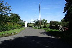
 Sunderland | |
| Location | |
| Grid reference: | NY178354 |
| Location: | 54°42’25"N, 3°16’30"W |
| Data | |
| Population: | 190 (1990) |
| Post town: | Allerdale |
| Postcode: | CA13 |
| Dialling code: | 01768 |
| Local Government | |
| Council: | Cumberland |
| Parliamentary constituency: |
Copeland |
Sunderland is a hamlet within the Lake District National Park, in the parish of Blindcrake in the county of Cumberland.
Nearby places include such towns as Cockermouth, Keswick, Bothel and Aspatria. The nearest railway station is at Aspatria.
Outside links
| ("Wikimedia Commons" has material about Sunderland, Cumberland) |
References

This Cumberland article is a stub: help to improve Wikishire by building it up.
