Monaghan: Difference between revisions
m clean up, typos fixed: Nine Years War → Nine Years' War |
m clean up |
||
| Line 23: | Line 23: | ||
The Battle of Clontibret between the forces of Hugh O'Neill, The O'Neill and those of Queen Elizabeth was fought in northern Monaghan in May 1595. The territory of Monaghan had earlier been wrested from the control of the MacMahon sept in 1591, when the leader of the MacMahons was hanged by authority of the Dublin government; this was one of the events that led to the Nine Years' War and the Tudor conquest of Ireland. | The Battle of Clontibret between the forces of Hugh O'Neill, The O'Neill and those of Queen Elizabeth was fought in northern Monaghan in May 1595. The territory of Monaghan had earlier been wrested from the control of the MacMahon sept in 1591, when the leader of the MacMahons was hanged by authority of the Dublin government; this was one of the events that led to the Nine Years' War and the Tudor conquest of Ireland. | ||
On the Hill of Lech, the ''Hill of the Stone'' was the inauguration stone of the Mac Mahons. It overlooks Ballagh Lough to the west, which was once known as Lough Leck. Situated | On the Hill of Lech, the ''Hill of the Stone'' was the inauguration stone of the Mac Mahons. It overlooks Ballagh Lough to the west, which was once known as Lough Leck. Situated three miles south-west of Monaghan, the petrosomatoglyph was last used in 1595, but was destroyed by a farm owner in 1809. It is said to be built into the wall of a mill. | ||
The [[Ulster Canal]] through Monaghan linking the [[River Blackwater, County Armagh|River Blackwater]] at [[Moy, Tyrone|Moy]] with the [[River Erne]] near [[Clones]] was built between 1825 and 1842. By the time it was completed, competition in the form of the Ulster Railway from Belfast to Clones was already under construction,<ref>{{cite book |last=Hajducki |first=S. Maxwell |authorlink=|year=1974 |title=A Railway Atlas of Ireland |location=Newton Abbott |publisher=David & Charles |isbn=0-7153-5167-2 |at=map 9}}</ref> which ensured that the canal was never a commercial success and it was formally abandoned in 1931. | The [[Ulster Canal]] through Monaghan linking the [[River Blackwater, County Armagh|River Blackwater]] at [[Moy, Tyrone|Moy]] with the [[River Erne]] near [[Clones]] was built between 1825 and 1842. By the time it was completed, competition in the form of the Ulster Railway from Belfast to Clones was already under construction,<ref>{{cite book |last=Hajducki |first=S. Maxwell |authorlink=|year=1974 |title=A Railway Atlas of Ireland |location=Newton Abbott |publisher=David & Charles |isbn=0-7153-5167-2 |at=map 9}}</ref> which ensured that the canal was never a commercial success and it was formally abandoned in 1931. | ||
| Line 52: | Line 52: | ||
[[File:Church Square, Monaghan.jpg|right|thumb|200px|Church Square, Monaghan]] | [[File:Church Square, Monaghan.jpg|right|thumb|200px|Church Square, Monaghan]] | ||
Church Square is very much an environment in which the civic pride of Victorian improvers lives on in the satisfying essay in the Ruskinian-Gothic style that is the Bank of Ireland building, as much as in the peaks of St | Church Square is very much an environment in which the civic pride of Victorian improvers lives on in the satisfying essay in the Ruskinian-Gothic style that is the Bank of Ireland building, as much as in the peaks of St Patrick's [[Church of Ireland]] and the Dawson Obelisk. One of the most interesting aspects of Monaghan's Victorian architectural heritage, which also includes the former railway station, the Orange Hall on North Road and the Westenra Hotel on the Diamond, is the rounded corners that connect the town's buildings from one street or square to the next. This practice of rounding corners in order to open up panoramic vistas was carried out with unprecedented frequency in the town of Monaghan and is still reflected today in the edifices of The Diamond, Church Square and Mill Street, helping to secure Monaghan's status as one of Ulster's more attractive large towns. | ||
==Economy== | ==Economy== | ||
Latest revision as of 12:39, 2 August 2017
| Monaghan Irish: Muineachán | |
| County Monaghan | |
|---|---|
 Monaghan Courthouse | |
| Location | |
| Grid reference: | H668338 |
| Location: | 54°14’53"N, 6°58’15"W |
| Data | |
| Population: | 6,637 (2011) |
| Local Government | |
Monaghan ('mʌnəhən) is the county town of County Monaghan, one of the three Ulster counties in the Republic of Ireland. Its population at the 2011 census was 7,452 including suburbs and environs.
The town is close to the border with the United Kingdom, where County Monaghan projects north between Fermanagh and County Armagh. It is found on the N2 road between Dublin, Londonderry and Letterkenny.
Name
The Irish name Muineachán derives from a diminutive plural form of the Irish word muine meaning "brake" (a thickly overgrown area) or sometimes "hillock". Patrick Weston Joyce interpreted this as "a place full of little hills or brakes",[1] which may be a reference to the numerous drumlins in the area.
History
The Battle of Clontibret between the forces of Hugh O'Neill, The O'Neill and those of Queen Elizabeth was fought in northern Monaghan in May 1595. The territory of Monaghan had earlier been wrested from the control of the MacMahon sept in 1591, when the leader of the MacMahons was hanged by authority of the Dublin government; this was one of the events that led to the Nine Years' War and the Tudor conquest of Ireland.
On the Hill of Lech, the Hill of the Stone was the inauguration stone of the Mac Mahons. It overlooks Ballagh Lough to the west, which was once known as Lough Leck. Situated three miles south-west of Monaghan, the petrosomatoglyph was last used in 1595, but was destroyed by a farm owner in 1809. It is said to be built into the wall of a mill.
The Ulster Canal through Monaghan linking the River Blackwater at Moy with the River Erne near Clones was built between 1825 and 1842. By the time it was completed, competition in the form of the Ulster Railway from Belfast to Clones was already under construction,[2] which ensured that the canal was never a commercial success and it was formally abandoned in 1931.
The Ulster Railway linked Monaghan with Armagh and Belfast in 1858 and with the Dundalk and Enniskillen Railway at Clones in 1863.[3] It became part of the Great Northern Railway in 1876.[4]
The separation of the Irish Free State from the United Kingdom in 1922 turned the boundary with County Armagh into an international frontier, after which trains were routinely delayed by customs inspections. In 1957 the Government of Northern Ireland made the GNR Board close the line between Portadown and the border, giving the GNRB no option but to withdraw passenger services between the border and Clones as well.[5] CIÉ took over the remaining section of line between Clones, Monaghan and Glaslough in 1958 but withdrew goods services between Monaghan and Glaslough in 1959 and between Clones and Monaghan in 1960, leaving Monaghan with no railway service.[5]
In February 1919 the first self-consciously proclaimed soviet in the United Kingdom was established at Monaghan Lunatic Asylum.[6] This led to the claim by Joseph Devlin in the House of Commons of the United Kingdom that "that the only successfully conducted institutions in Ireland are the lunatic asylums"[7]
On 17 May 1974 an Ulster loyalist car bomb exploded in the Friday evening rush hour killing seven people. It was detonated outside Greacen's public house on North Road in a car that had been stolen earlier that afternoon in Portadown. The bomb killed seven, injured scores of civilians and caused extensive damage to the fabric of the town with North Road and Mill Street among the areas worst affected. This was one of the few incidents in the Republic during The Troubles; three other bombs exploded on the same day in Dublin in what became known as the Dublin and Monaghan bombings. The Ulster loyalist paramilitary group the Ulster Volunteer Force claimed responsibility in 1993.
A monument in memory of the victims was unveiled by the eighth President of Ireland Mary McAleese on 17 May 2004, on the occasion of the 30th anniversary of the atrocity. The sandstone and metal column containing seven light wells bearing the names of each of the seven victims of the bombing was designed by Ciaran O'Cearnaigh and stands as a reminder of one of the darkest days in Ireland's modern history.
Town layout and architecture
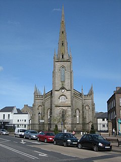
The centre of the town is made up of four interconnecting squares: Market Square (or Street), Church Square, The Diamond and Old Cross Square.
Dating from the seventeenth century, the oldest remaining architectural feature in Monaghan town is the "Old Cross" - located in Old Cross Square. It is not fully agreed that it is in fact a cross, but may in fact have been a seventeenth-century sundial. It was originally located in the Diamond, the traditional centre of the town, and was used as a hiring cross and for the attaching of proclamations. It was moved to its present location in 1876 to allow for the construction of the Rossmore Memorial.
Two landmark buildings remain from the eighteenth century; Aviemore House (built in 1760) on Mill Street and the "extremely elegant" Market House (from 1792) on Market Square.[8]
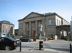
Monaghan is notable for the quality of its nineteenth-century architecture, which adds a sense of dignity to the attractive town centre and its environs. Of its Victorian buildings, the courthouse on Church Square by Joseph Welland, which was built in 1830, is the most stately. With its sandstone facade of Doric columns supporting a pediment that bears the royal arms of the House of Hanover, Monaghan Courthouse constitutes an integral part of Church Square.
The Rossmore Memorial in The Diamond was built in 1876 as a memorial to the 4th Baron Rossmore, who died after a hunting accident at Windsor Castle in 1874. This Victorian monument, described by architectural historian C.E.B. Brett as "formidable and striking"[9] is octagonal in shape, with central marble columns supporting a fountain. Around it, the eight grey columns support the pinnacled superstructure which rises to a dome. The dome is surmounted by a spire supported by yet more columns. The letters of Rossmore (also 8 in number) are spaced out around the monument.
The Gothic-Revival Roman Catholic St Macartan's Cathedral by J J McCarthy is recognized as being "one of McCarthy's best works: an excellent example of the High Victorian ecclesiastical style at its best, rich without ever being over-ornate".[10] Construction work began in 1861 and the it was finally dedicated in 1892. The Cathedral sits on imposing site overlooking the town. Occupying a similarly commanding site on the opposite side of the town is St Macartan's College for boys (from 1840), a 17-bay classical structure with a bell tower and private chapel, by the Newry-born architect Thomas Duff.
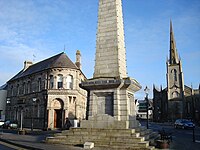
Church Square is very much an environment in which the civic pride of Victorian improvers lives on in the satisfying essay in the Ruskinian-Gothic style that is the Bank of Ireland building, as much as in the peaks of St Patrick's Church of Ireland and the Dawson Obelisk. One of the most interesting aspects of Monaghan's Victorian architectural heritage, which also includes the former railway station, the Orange Hall on North Road and the Westenra Hotel on the Diamond, is the rounded corners that connect the town's buildings from one street or square to the next. This practice of rounding corners in order to open up panoramic vistas was carried out with unprecedented frequency in the town of Monaghan and is still reflected today in the edifices of The Diamond, Church Square and Mill Street, helping to secure Monaghan's status as one of Ulster's more attractive large towns.
Economy
The town is a centre for the timber-frame house building industry with Kingspan Century being the largest of its kind in Europe. It is also the centre of a thriving agri business most notable of which is the mushroom industry. Engineering also features in the region with both Moffett[11] and Combilift[12] major participants in the materials handling market.[13]
There is a campaign to boost tourism by reopening the Ulster Canal in a scheme which would eventually allow boats to travel from towns in Northern Ireland, such as Newry, by way of Monaghan to places as far south as Limerick, as well as Dublin.
Monaghan once had a thriving furniture manufacturing industry. Since 1990, this has diminished greatly under global competition. However, notable manufacturers such as Rossmore Furniture (which took its name from the magnificent Rossmore Forest Park, situated just outside the town) continue to operate from the town.
Culture
Monaghan continues to host one of Ireland's most prestigious and established blues festivals in the country;[14] the Harvest Time Blues Festival. It is hosted every September across Monaghan Town.[15]
The Fiddler of Oriel Muineachán Competition (also known as Féile Oriel) first held in 1969 returned in 2009 to celebrate its fortieth anniversary.[16] It is held every May Bank Holiday weekend.
Founded in 1974, Monaghan County Museum is located in a mid-Victorian stone building of three stories, formerly two separate town houses, on Hill Street. It aims to acquaint its visitors with the history of County Monaghan and its people.
Sport
- Football: Monaghan United FC
Gallery of old pictures
-
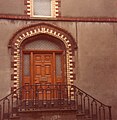
Entrance detail of Masonic Hall, 1989
-
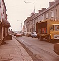
Glaslough Street, 1989, looking west
-
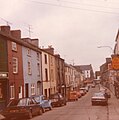
Glaslough Street, 1989, looking east
-
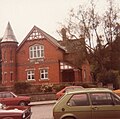
Orange Hall, North Road, 1989
-
Monaghan railway station
Outside links
| ("Wikimedia Commons" has material about Monaghan) |
References
- ↑ Patrick Weston Joyce: Irish Local Names Explained (1870)
- ↑ Hajducki, S. Maxwell (1974). A Railway Atlas of Ireland. Newton Abbott: David & Charles. map 9. ISBN 0-7153-5167-2.
- ↑ Hajducki, 1974, map 8
- ↑ Hajducki, op. cit., page xiii
- ↑ 5.0 5.1 Hajducki, op. cit., map 39
- ↑ Kostick, Conor (1996). Revolution in Ireland: Popular Militancy, 1917-1923. London: Pluto Press. p. 70.
- ↑ Hansard, 20 February 1919, accessed 18 July 2010
- ↑ Brett, C.E.B. "Historic Buildings, Groups of Buildings and Areas of Architectural Importance in the Town of Monaghan". Belfast, Ulster Architectural Heritage Society, 1970. p. 16.
- ↑ Brett, C.E.B. "Historic Buildings, Groups of Buildings and Areas of Architectural Importance in the Town of Monaghan". Belfast, Ulster Architectural Heritage Society, 1970. p. 10.
- ↑ Brett, C.E.B. "Historic Buildings, Groups of Buildings and Areas of Architectural Importance in the Town of Monaghan". Belfast, Ulster Architectural Heritage Society, 1970. p. 26.
- ↑ Maurice Moffett Ltd.
- ↑ Combilift Inc.
- ↑ "Combilift 2 . Background". Enterprise Ireland. 2010. http://www.enterprise-ireland.com/ebusiness/Case_studies/combilift/combilift_p2.asp. Retrieved 5 October 2010.
- ↑ Monaghan Post, 2007-09-06. "Who's Behind the Blues?"
- ↑ www.HarvestBlues.ie
- ↑ Fiddler of Oriel Muineachán Competition
