Cold Fell (Pennines): Difference between revisions
Jump to navigation
Jump to search
Created page with "{{Infobox hill |name=Cold Fell |picture=Cold Fell - geograph.org.uk - 213099.jpg |picture caption=Summit of Cold Fell |os grid ref=NY605556 |latitude=54.8939 |longitude=-2.616..." |
mNo edit summary |
||
| Line 6: | Line 6: | ||
|latitude=54.8939 | |latitude=54.8939 | ||
|longitude=-2.6163 | |longitude=-2.6163 | ||
|range= | |range=King's Forest of Geltsdale | ||
|height=2,037 feet | |height=2,037 feet | ||
|height_m=621 m | |height_m=621 m | ||
Latest revision as of 17:37, 7 July 2017
| Cold Fell | |||
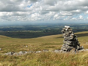
 Summit of Cold Fell | |||
|---|---|---|---|
| Range: | King's Forest of Geltsdale | ||
| Summit: | 2,037 feet NY605556 54°53’38"N, 2°36’59"W | ||
Cold Fell is a mountain in the northern Pennines, within the King's Forest of Geltsdale in eastern Cumberland.
Cumberland is a county rich in high fells, a few exceeding 3,000 feet and a great many exceeding 2,000 feet: Cold Fell is the is the northernmost 2,000-foot fell in the county. It is enrolled as a 'marilyn' due to its relative prominence (551 feet).