Yorke Bay: Difference between revisions
Created page with "thumb|250px|Penguins at Gypsy Cove in Yorke Bay File:Stanley and Stanley Harbour.svg|right|thumb|350px|Map of the Stanley area, showing Yorke Bay and..." |
No edit summary |
||
| Line 1: | Line 1: | ||
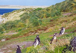
[[File:Gypsy-Cove.jpg|thumb|250px|Penguins at Gypsy Cove in Yorke Bay]] | [[File:Gypsy-Cove.jpg|thumb|250px|Penguins at Gypsy Cove in Yorke Bay]] | ||
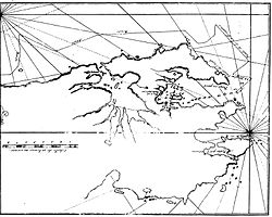
[[File:Stanley and | [[File:Stanley - Port, airport and York Bay.svg|right|thumb|350px|Map of the Stanley area, showing Yorke Bay and Gypsy Cove]] | ||
{{territory|Falkland Islands}} | {{territory|Falkland Islands}} | ||
'''Yorke Bay''' is a bay on [[East Falkland]] in the [[Falkland Islands]], on the south shore of [[Port William, Falkland Islands|Port William]], the inlet into which [[Stanley Harbour]] opens, half a mile north of [[Port Stanley Airport]] and four miles to the northeast of the capital, [[Stanley, Falkland Islands|Stanley]]. | '''Yorke Bay''' is a bay on [[East Falkland]] in the [[Falkland Islands]], on the south shore of [[Port William, Falkland Islands|Port William]], the inlet into which [[Stanley Harbour]] opens, half a mile north of [[Port Stanley Airport]] and four miles to the northeast of the capital, [[Stanley, Falkland Islands|Stanley]]. | ||
Latest revision as of 20:21, 11 May 2017


Yorke Bay is a bay on East Falkland in the Falkland Islands, on the south shore of Port William, the inlet into which Stanley Harbour opens, half a mile north of Port Stanley Airport and four miles to the northeast of the capital, Stanley.
The bay indents the shore of the peninsula on which the airport is built (which is connected to the mainland by the Boxer Bridge and a narrow isthmus known as "The Neck"), and so most ships approaching Stanley pass Yorke Bay and Gypsy Cove, on the west side of Yorke Bay.
To the south of the Yorke Bay is Canopus Hill.
Before the war in 1982, Yorke Bay was a popular summer swimming and recreation site for local residents.
The bay is known internationally as a breeding site for the threatened Magellanic penguin.
Falklands War
During the night of 1 / 2 April 1982, Argentina invaded the Falkland Islands, with an initial landing south of Stanley. The Argentine main invasion force though landed in Yorke Bay in the early hours of 2 April 1982.
Having themselves landed there, the Argentines recognised Yorke Bay, Surf Bay and Rookery Bay (the latter two due east of Stanley) as the bays close to both Stanley and the airport with beaches capable of supporting an amphibious landing on the east coast of East Falkland. That being so that heavily mined the beaches to prevent a British landing. In the event however, the British forces landed away from Stanley on the western shore of East Falkland and marched on Stanley from the landward side.

Minefields
Yorke Bay beach was heavily mined by the Argentine forces during the Falklands War of 1982, with hundreds of anti-personnel and anti-tank minimum metal mines. After the liberation of the islands, the many minefields around the airport remained and were never removed.[1]
The beach, once a popular recreation beach, has been off-limits since the war: the entire northern coast of the Port Stanley Airport peninsula (including Yorke Bay) have been fenced and marked as a prohibited area since a tractor and bulldozer were destroyed by an anti-tank mine while attempting to lay a pipeline in the area in 1986.[2]
A Cranfield University assessment dismissing the feasibility of demining Yorke Bay noted that the sand dunes had expanded considerably since 1982, burying the mines too deeply for advanced detection equipment and disrupting the orderly lines in which they were originally laid. At the same time, however, any large storm could potentially cause large numbers of mines to suddenly resurface. To recover them all would thus require mass excavation of the entire beach area with armoured digging equipment, a task that would be expensive, dangerous, unlikely to definitively succeed, and certain to do severe damage to the Magellanic penguin rookeries, which are deemed "internationally important".[3] Local residents and officials have also expressed opposition to the idea of such extensive mine clearance, and the Governor, Howard Pearce, stated that the high probability that "only 95 percent" of the mines would end up being accounted for would actually "bring a sense of complacency to the community and increase rather than reduce the chance of injury."[2]
The penguins in the meantime have benefited from their undisturbed control of the beaches (being too small to set off the mines), resulting in an unplanned, man-made wildlife refuge where tourists can view the penguins safely from a distance without disrupting their habitat.
Nevertheless, the Ottawa Mine Ban Treaty of 1997 compels signatories to clear minefields in territory under their control, and so the British government has begun a challenging mine clearance programme.[4]
Outside links
- Location map: 51°40’41"S, 57°48’11"W
References
- ↑ Falkland Islands Navigational Charts & Minefield Map; pg. 15-16, 2011 Harbour Info Brochure
- ↑ 2.0 2.1 CNN. "Penguins Stay Snug and Secure in Minefield". Sep 27, 2005
- ↑ Field survey report, Cranfield University, 9 July 2007. pg. 44, 101
- ↑ The Falklands penguins that would not explode - Magazine, BBC News, 7 May 2017]