Drigg Holme Packhorse Bridge: Difference between revisions
Jump to navigation
Jump to search
Created page with "{{Infobox bridge |name=Drigg Holme Packhorse Bridge |county=Cumberland |picture=Drigg Holme Packhorse Bridge - geograph.org.uk - 3070747.jpg |picture caption=Drigg Holme Packh..." |
m RB moved page Drigg Holmes Packhorse Bridge to Drigg Holme Packhorse Bridge |
(No difference)
| |
Latest revision as of 12:29, 11 May 2017
| Drigg Holme Packhorse Bridge | |
| Cumberland | |
|---|---|
 Drigg Holme Packhorse Bridge | |
| Location | |
| Type: | Packhorse bridge |
| Carrying: | Bridleway |
| Crossing: | River Irt |
| Location | |
| Grid reference: | SD076987 |
| Location: | 54°22’32"N, 3°25’21"W |
| Structure | |
| Type: | Packhorse bridge |
| History | |
| Information | |
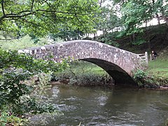
The Drigg Holme Packhorse Bridge is a single-span packhorse bridge over the River Irt at Drigg, close to the coast of Cumberland. It carries public bridleway and is not open to wheeled traffic.
The bridge is believed to have been built in the Middle Ages, and certainly this is a route across the river at least that old. It was built to carry packhorses, which were the main form of transport in the rough lands of Cumberland until recent times. Today it is a Scheduled Ancient Monument.[1]
References
- ↑ National Heritage List 1007107: Drigg Holme Packhorse Bridge: scheduled monument