Difference between revisions of "Broadmeadows"
From Wikishire
(Created page with "{{Infobox town |name=Broadmeadows |county=Selkirkshire |picture=Broadmeadows and Yarrow Valley - geograph.org.uk - 439007.jpg |picture caption=Broadmeadows and the Yarrow Vall...") |
(No difference)
|
Latest revision as of 21:30, 1 February 2017
| Broadmeadows | |
| Selkirkshire | |
|---|---|
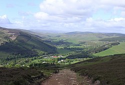
 Broadmeadows and the Yarrow Valley | |
| Location | |
| Grid reference: | NT411302 |
| Location: | 55°33’46"N, 2°56’5"W |
| Data | |
| Post town: | Selkirk |
| Postcode: | TD7 |
| Local Government | |
| Council: | Scottish Borders |
| Parliamentary constituency: |
Berwickshire, Roxburgh and Selkirk |
Broadmeadows is a little village in Selkirkshire, just above the village of Yarrowford. It is within the valley of the Yarrow Water. The A708 runs down the Yarrow Valley by Yarrowford to the county town, Selkirk.
There is a youth hostel in the village.
Places nearby include Boleside, Bowhill, Caddonfoot, Ettrickbridge, Lindean, Philiphaugh, Sundhope, Yarrow Water and Yarrowford.
Outside links
- SCRAN File: Opening of the first Youth Hostel at Broadmeadows, Yarrow Valley
- SCRAN File: Shepherd and family at Yarrowford, Broadmeadows
- Scottish Youth Hostel Association: Broadmeadows hostel, the first SYHA hostel in Scotland, started in 1931
- Selkirk News: Flooding in Selkirk and Broadmeadows
- The Sir Walter Scott Way