Whiteside Law: Difference between revisions
Jump to navigation
Jump to search
Created page with "{{Infobox hill |name=Whiteside Law |county=Midlothian |range=Moorfoot Hills |picture=Whiteside Law and the Blackhope Water - geograph-4686300.jpg |picture caption=Whiteside La..." |
m RB moved page Whiteside Law, Midlothian to Whiteside Law |
(No difference)
| |
Latest revision as of 21:57, 26 November 2016
| Whiteside Law | |||
| Midlothian | |||
|---|---|---|---|
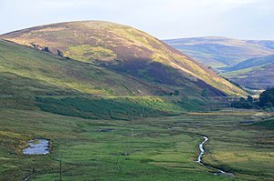
 Whiteside Law and the Blackhope Water | |||
| Range: | Moorfoot Hills | ||
| Summit: | 1,490 feet NT358509 55°44’53"N, 3°1’27"W | ||
Whiteside Law is a modest hill of 1,490 feet in the Moorfoot Hills of Midlothian.
The Blackfoot Water is forced into a long loop around the hill, running down the west side of the hill, to be joined by the Dewar Burn under the gaze of the mountain, and the Ladyside Burn soon after, before the combined waters, by then name of the Heriot Water, then run along the east side of the hill.