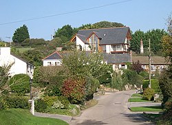
Bolingey: Difference between revisions
Jump to navigation
Jump to search
Created page with "{{Infobox town |name=Bolingey |cornish =Melinji |county=Cornwall |picture=Bolingey - geograph.org.uk - 66038.jpg |picture caption=Bolingey |os grid ref=SW762532 |latitude=50.3..." |
No edit summary |
||
| Line 15: | Line 15: | ||
|constituency=Truro & Falmouth | |constituency=Truro & Falmouth | ||
}} | }} | ||
'''Bolingey''' is a village on the north coast of [[Cornwall]]. It is half a mile south of the small seaside resort of [[Perranporth]]. It is in the | '''Bolingey''' is a village on the north coast of [[Cornwall]]. It is half a mile south of the small seaside resort of [[Perranporth]]. It is in the parish of [[Perranzabuloe]]. | ||
(There is also a place called Bolingey in the civil parish of St Mawgan.) | (There is also a place called Bolingey in the civil parish of St Mawgan.) | ||
Latest revision as of 18:03, 15 July 2016
| Bolingey Cornish: Melinji | |
| Cornwall | |
|---|---|
 Bolingey | |
| Location | |
| Grid reference: | SW762532 |
| Location: | 50°20’11"N, 5°8’37"W |
| Data | |
| Post town: | Perranporth |
| Postcode: | TR6 |
| Dialling code: | 01872 |
| Local Government | |
| Council: | Cornwall |
| Parliamentary constituency: |
Truro & Falmouth |
Bolingey is a village on the north coast of Cornwall. It is half a mile south of the small seaside resort of Perranporth. It is in the parish of Perranzabuloe.
(There is also a place called Bolingey in the civil parish of St Mawgan.)
Sports teams
- Rugby: Bolingey Barbarians[1], formed in 1990
Outside links
| ("Wikimedia Commons" has material about Bolingey) |
