Ringford: Difference between revisions
Jump to navigation
Jump to search
Created page with "{{Infobox town |name=Ringford |county=Kirkcudbrightshire |picture= |picture caption= |os grid ref=NX689578 |latitude=54.89768 |longitude=-4.04586 |postcode= |post town= |popul..." |
mNo edit summary |
||
| Line 2: | Line 2: | ||
|name=Ringford | |name=Ringford | ||
|county=Kirkcudbrightshire | |county=Kirkcudbrightshire | ||
|picture= | |picture=Ringford from Low Barcaple - geograph.org.uk - 71193.jpg | ||
|picture caption= | |picture caption=Ringford from Low Barcaple | ||
|os grid ref=NX689578 | |os grid ref=NX689578 | ||
|latitude=54.89768 | |latitude=54.89768 | ||
Revision as of 23:31, 21 June 2016
| Ringford | |
| Kirkcudbrightshire | |
|---|---|
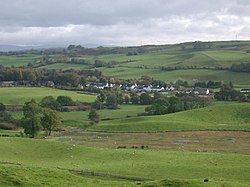
 Ringford from Low Barcaple | |
| Location | |
| Grid reference: | NX689578 |
| Location: | 54°53’52"N, 4°2’45"W |
| Data | |
| Local Government | |
Ringford is a village in Kirkcudbrightshire, within the Galloway Hills. The village sits beside the Tarff Water, a few miles upstream of is meeting with the River Dee at Tongland.
Ringford is to be found just north of the A75 road making its way from Castle Douglas over towards the Wigtownshire ports for Ulster. It is about four miles north of the county town, Kirkcudbright.
The village has a war memorial and a village hall. The Kirkcudbright Railway used to run past the village, the nearest stop being Tarff.
Outside links
| ("Wikimedia Commons" has material about Ringford) |

This Kirkcudbrightshire article is a stub: help to improve Wikishire by building it up.
