Brierley Hill: Difference between revisions
| Line 48: | Line 48: | ||
[[File:Brierley Hill Nick - geograph.org.uk - 1275903.jpg|right|thumb|200px|Brierley Hill Police Station]] | [[File:Brierley Hill Nick - geograph.org.uk - 1275903.jpg|right|thumb|200px|Brierley Hill Police Station]] | ||
There are current plans to extend to the Midland Metro, reopening the railway line north of Brierley Hill with light rail services providing a link to the existing Metro line in [[Wednesbury]].<ref>{{cite news|last=Chadwick|first=Edward|title=Plans for £1.1 bn West Midlands Metro system unveiled|url=http://www.birminghampost.net/news/west-midlands-transport-news/2010/11/25/plans-for-1-1-bn-west-midlands-metro-system-unveiled-65233-27711546/|accessdate=19th November 2012|newspaper=Birmingham Post|date=November 25th 2010}}</ref> | There are current plans to extend to the [[Midland Metro]], reopening the railway line north of Brierley Hill with light rail services providing a link to the existing Metro line in [[Wednesbury]].<ref>{{cite news|last=Chadwick|first=Edward|title=Plans for £1.1 bn West Midlands Metro system unveiled|url=http://www.birminghampost.net/news/west-midlands-transport-news/2010/11/25/plans-for-1-1-bn-west-midlands-metro-system-unveiled-65233-27711546/|accessdate=19th November 2012|newspaper=Birmingham Post|date=November 25th 2010}}</ref> | ||
==Outside links== | ==Outside links== | ||
Latest revision as of 11:44, 6 June 2016
| Brierley Hill | |
| Staffordshire | |
|---|---|
 The Brierley Hill flats | |
| Location | |
| Grid reference: | SO915868 |
| Location: | 52°28’46"N, 2°7’28"W |
| Data | |
| Post town: | Brierley Hill |
| Postcode: | DY5 |
| Dialling code: | 01384 |
| Local Government | |
| Council: | Dudley |
| Parliamentary constituency: |
Dudley South |
Brierley Hill is a small town in Staffordshire within the Black Country, sfound some 2½ miles south of central Dudley and 2 miles north of Stourbridge. It has a population of around 9,500 and is heavily industrialised.
Brierley Hill is best known for glass and steel manufacturing, although the industry has declined considerably since the 1970s. One of the largest factories in the area was the Round Oak Steelworks, which was closed down and redeveloped in the 1980s to become the Merry Hill Shopping Centre.
The name Brierley Hill is from the Old English words brer leag; "Brier clearing".
History
The town we see today is a product of the Industrial Revolution, Brierley Hill has a relatively recent history, with the first written records of the town dating back to the 17th century. Originally established as a settlement in the woodland of Pensnett Chase, it began expanding rapidly following the chase's enclosure in 1748, and was first recorded on a map in 1785 after the mapping of the Stourbridge Canal.

Brierley Hill had become heavily industrialized by the beginning of the 19th century, with a number of quarries, collieries, glass works, and iron works emerging. A National School was opened in the town in 1835, and a market area had developed along the High Street.
By the start of the 20th century, the raw material deposits had become depleted, leading to the closure of many of the industries in the area. The decline in manufacturing resulted in an unemployment rate of 25% in Brierley Hill by the early 1980s,[1] with the closure of the Round Oak Steelworks in December 1982 resulting in a further 1,300 redundancies. The steelworks site, along with the adjacent Merry Hill Farm, were subsequently designated as an Enterprise Zone, and were redeveloped to create the Merry Hill Shopping Centre and The Waterfront business park.[2]
In recent years, proposals have been drawn up by the local authority to regenerate Brierley Hill, with the Brierley Hill Regeneration Partnership formed to improve the town over a period of 10 years, by investing in the infrastructure and increasing the number of homes and job opportunities.[3]
Churches

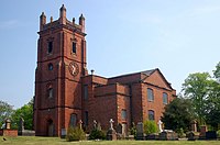
The first recorded church building in Brierley Hill was St. Michael's Chapel, which was built in 1765 by public subscription. It became a parish church in 1842, covering the areas of Brockmoor, Delph, and Quarry Bank.
In 1872, construction commenced on a Roman Catholic church to serve the vast new population of Irish labourers arriving in the town. St Mary's Church was designed by E W Pugin, it was completed in 1873 and upon completion, consisted of a nave, sanctuary, aisle and side chapel.
About the town

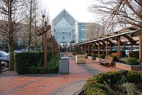
The Merry Hill Shopping Centre is located immediately east of Brierley Hill. One of the largest shopping centres in the UK, it was built in the 1980s on the grounds of Merry Hill Farm, the last working urban farm in the Black Country, and the Round Oak Steelworks. The adjacent Waterfront office complex was also built on the former steelworks site, though with the onset of the recession in the late 2000s around half of its office units have become empty, with an application for government-funded Enterprise Zone status rejected.[4]
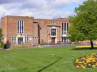
Brierley Hill Town Hall stands on Bank Street in the town centre. It is now no longer used as a town hall, the giganticism of local administration having give these towns hereabouts bureaucrats in sitting in Dudley, but it is still an important town venue. Several of Slade's first gigs during the early 1970s, were played here although none of the members were actually from Brierley Hill.
Transport links
Brierley Hill is situated along the main A461 road between Stourbridge and Dudley, with other roads providing connections to neighbouring locations. It is also served by numerous bus services, with a bus station situated at the Merry Hill Shopping Centre, and several bus stops along the main High Street. Buses from Brierley Hill and Merry Hill provide links to central Dudley, Halesowen, Stourbridge, Walsall, West Bromwich, and Wolverhampton, among others.
From 1850 to 1962, Brierley Hill was served by a railway station for passengers on the Oxford-Worcester-Wolverhampton Line, before passenger services were withdrawn. This was before the Beeching Axe came into effect. The section of line from Stourbridge to Brierley Hill is still in use for goods trains, with a railway steel terminal opening in 1986, but the line northbound to Dudley has been closed since 1993. Currently, the nearest passenger railway station is Cradley Heath, over a mile south-east of the town.

There are current plans to extend to the Midland Metro, reopening the railway line north of Brierley Hill with light rail services providing a link to the existing Metro line in Wednesbury.[5]
Outside links
References
- ↑ "History of Brierley Hill". Brierley Hill Regeneration Partnership. Archived from the original on 2008-04-05. http://web.archive.org/web/20080405152203/http://www.brierleyhill.org/subpage.php?page_id=27. Retrieved 2008-08-05.
- ↑ "Round Oak Steel Works Ltd.". Access to Archives. The National Archives. http://www.nationalarchives.gov.uk/a2a/records.aspx?cat=145-drou&cid=0#0. Retrieved 17th November 2012.
- ↑ "Our vision". Brierley Hill Regeneration Partnership. Archived from the original on 2008-04-06. http://web.archive.org/web/20080406040601/http://www.brierleyhill.org/subpage.php?page_id=3. Retrieved 2008-08-05.
- ↑ "Hopes for the future as city status bid rejected". Express & Star. March 14th, 2012. http://www.expressandstar.com/news/2012/03/14/hopes-for-the-future-as-city-status-bid-rejected/. Retrieved 19th November 2012.
- ↑ Chadwick, Edward (November 25th 2010). "Plans for £1.1 bn West Midlands Metro system unveiled". Birmingham Post. http://www.birminghampost.net/news/west-midlands-transport-news/2010/11/25/plans-for-1-1-bn-west-midlands-metro-system-unveiled-65233-27711546/. Retrieved 19th November 2012.