Cambo: Difference between revisions
Jump to navigation
Jump to search
Created page with "{{Infobox town |name=Cambo |county=Northumberland |picture=Holy Trinity Church, Cambo - geograph.org.uk - 147493.jpg |picture caption=Holy Trinity Church |os grid ref=NZ02585..." |
No edit summary |
||
| Line 14: | Line 14: | ||
|constituency=Hexham | |constituency=Hexham | ||
}} | }} | ||
'''Cambo''' is a village in [[Northumberland]] | '''Cambo''' is a village and parish in [[Northumberland]]. It is about eleven miles to the west of [[Morpeth]] in the south of the county, at the junction of the B6342 and B6343 roads. It is part of Wallington Estate, and is a National Trust village. | ||
==Landmarks== | ==Landmarks== | ||
Latest revision as of 23:03, 14 December 2015
| Cambo | |
| Northumberland | |
|---|---|
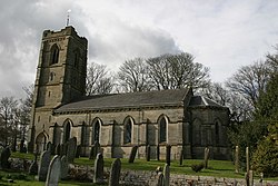
 Holy Trinity Church | |
| Location | |
| Grid reference: | NZ025855 |
| Location: | 55°9’50"N, 1°57’43"W |
| Data | |
| Post town: | Morpeth |
| Postcode: | NE61 |
| Dialling code: | 01670 |
| Local Government | |
| Council: | Northumberland |
| Parliamentary constituency: |
Hexham |
Cambo is a village and parish in Northumberland. It is about eleven miles to the west of Morpeth in the south of the county, at the junction of the B6342 and B6343 roads. It is part of Wallington Estate, and is a National Trust village.
Landmarks
Wallington Hall, the 17th-century hall, is just south of the village, and has been owned by the National Trust since 1942.
In Cambo itself, Holy Trinity church dates from 1842, with a west tower added in 1884. The village post office is housed in a three-storey 16th-century bastle house.[1]
Miscellany
Capability Brown, the 18th-century landscape gardener, was educated at the village school. He was born at nearby Kirkharle.
Outside links
| ("Wikimedia Commons" has material about Cambo) |
References
- ↑ Nikolaus Pevsner, The Buildings of England: Northumberland, p.210.
