Little Washbourne: Difference between revisions
Jump to navigation
Jump to search
No edit summary |
No edit summary |
||
| Line 2: | Line 2: | ||
|name=Little Washbourne | |name=Little Washbourne | ||
|county 1=Gloucestershire | |county 1=Gloucestershire | ||
|county | |county 2=Worcestershire | ||
|picture=Little Washbourne Church - geograph.org.uk - 779548.jpg | |picture=Little Washbourne Church - geograph.org.uk - 779548.jpg | ||
|picture caption=St Mary's, Little Washborne | |picture caption=St Mary's, Little Washborne | ||
Revision as of 06:58, 11 December 2015
| Little Washbourne | |
| Gloucestershire, Worcestershire | |
|---|---|
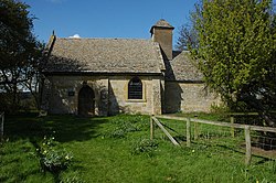
 St Mary's, Little Washborne | |
| Location | |
| Grid reference: | SO986339 |
| Location: | 52°0’14"N, 2°1’15"W |
| Data | |
| Postcode: | GL20 |
| Local Government | |
Little Washbourne is a hamlet in the Cotswolds, in Gloucestershire, or technically speaking in a small detached part of Worcestershire locally situate in Gloucestershire. It sits about half a mile south of Great Washbourne and the same distance west of Alderton, both of the latter being which is definitively within Gloucestershire.
The village is on the B4077 between Winchcombe and Tewkesbury, just a mile from main body of Worcestershire.
Little Washborne's parish church is St Mary's.
Outside links
| ("Wikimedia Commons" has material about Washbourne Little Washbourne) |

This Gloucestershire article is a stub: help to improve Wikishire by building it up.
