Barbaraville: Difference between revisions
Created page with "{{Infobox town |name=Barbaraville |gaelic=An Cladach |county=Cromartyshire |picture=Barbaraville - geograph.org.uk - 1201576.jpg |population= |os grid ref=NH748723 |latitude=5..." |
No edit summary |
||
| Line 2: | Line 2: | ||
|name=Barbaraville | |name=Barbaraville | ||
|gaelic=An Cladach | |gaelic=An Cladach | ||
|county=Cromartyshire | |county 1=Ross-shire | ||
|county 2=Cromartyshire | |||
|picture=Barbaraville - geograph.org.uk - 1201576.jpg | |picture=Barbaraville - geograph.org.uk - 1201576.jpg | ||
|population= | |population= | ||
| Line 14: | Line 15: | ||
|constituency=Caithness Sutherland and Easter Ross | |constituency=Caithness Sutherland and Easter Ross | ||
}} | }} | ||
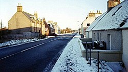
'''Barbaraville''' is a tiny village of [[Cromartyshire]], on the north shore of Nigg Bay (which indents the north of [[Cromarty Firth]]). It is not an ancient establishment: housing dates from 1820 onwards, when local people were allowed to build on packets of land from local estates at [[Balnagown]], [[Tarbat]] and [[Polnicol]]. | '''Barbaraville''' is a tiny village on the borders of [[Ross-shire]] and [[Cromartyshire]], on the north shore of Nigg Bay (which indents the north of [[Cromarty Firth]]). It is not an ancient establishment: housing dates from 1820 onwards, when local people were allowed to build on packets of land from local estates at [[Balnagown]], [[Tarbat]] and [[Polnicol]]. | ||
A similarly named "new" village, [[Jemimaville]], sits on the south shore of Cromarty Firth, on the [[Black Isle]], and also in Cromartyshire. | A similarly named "new" village, [[Jemimaville]], sits on the south shore of Cromarty Firth, on the [[Black Isle]], and also in Cromartyshire. | ||
Latest revision as of 12:47, 15 June 2015
| Barbaraville Gaelic: An Cladach | |
| Ross-shire, Cromartyshire | |
|---|---|

| |
| Location | |
| Grid reference: | NH748723 |
| Location: | 57°43’23"N, 4°6’8"W |
| Data | |
| Post town: | Invergordon |
| Postcode: | IV18 |
| Dialling code: | 01862 |
| Local Government | |
| Council: | Highland |
| Parliamentary constituency: |
Caithness Sutherland and Easter Ross |
Barbaraville is a tiny village on the borders of Ross-shire and Cromartyshire, on the north shore of Nigg Bay (which indents the north of Cromarty Firth). It is not an ancient establishment: housing dates from 1820 onwards, when local people were allowed to build on packets of land from local estates at Balnagown, Tarbat and Polnicol.
A similarly named "new" village, Jemimaville, sits on the south shore of Cromarty Firth, on the Black Isle, and also in Cromartyshire.
Consisting of about 170 households, there has been recent expansion with the creation of a retirement village at Highland Park which has added some 50 households to the community all of which are occupied by people over the age of 55.
Mull Hall[1] was originally the Jackdaw Hotel, and its restaurant and bar was a popular nightspot during the 1970s. It is now a residential home for the elderly.
Barbaraville has a small shop at Highland Park, a telephone kiosk and post box.
A garden centre, the Green Wellie, opened in 2012.
The nearest small towns are Tain to the northeast and Invergordon to the west.
Outside links
| ("Wikimedia Commons" has material about Barbaraville) |
