Worms Head: Difference between revisions
Jump to navigation
Jump to search
No edit summary |
|||
| Line 1: | Line 1: | ||
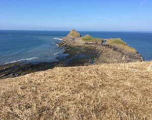
[[File:Worm's head.jpg|right|thumb|300px|Worms Head]] | [[File:Worm's head.jpg|right|thumb|300px|Worms Head]] | ||
{{county|Glamorgan}} | {{county|Glamorgan}} | ||
'''Worms Head''' is the long, thin headland marking the farthest end of [[Gower]], the broad peninsula in the west of [[Glamorgan]]. Like much of Gower, it is owned by the [[National Trust for Places of Historic Interest or Natural Beauty|National Trust]]. | '''Worms Head''' is the long, thin headland marking the farthest end of [[Gower]], the broad peninsula in the west of [[Glamorgan]]. Like much of Gower, it is owned by the [[National Trust for Places of Historic Interest or Natural Beauty|National Trust]]. | ||
Revision as of 19:37, 25 March 2015

Worms Head is the long, thin headland marking the farthest end of Gower, the broad peninsula in the west of Glamorgan. Like much of Gower, it is owned by the National Trust.
This is a craggy headland, an island at high tide. Remarkably, the remains of a fort stand on the dry part of the headland. The punishing sea has driven beneath the island to create "the Devil's Bridge", and at the end the waves have carved a blow hole.
Maps
- Wikishire map: 51°33’55"N, 4°19’23"W
- Streetmap: SS390877