Loch Awe: Difference between revisions
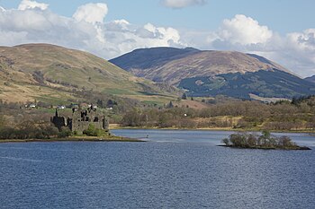
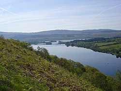
Created page with "right|thumb|350px|Kilchurn Castle on the loch right|thumb|250px|Loch Awe {{county|Argyll..." |
mNo edit summary |
||
| Line 37: | Line 37: | ||
==Outside links== | ==Outside links== | ||
{{commons}} | {{commons}} | ||
*Map: {{wmap| | *Map: {{wmap|56.298|-5.235}} | ||
*[http://www.loch-awe.com/ The Loch Awe community web site] | *[http://www.loch-awe.com/ The Loch Awe community web site] | ||
Latest revision as of 14:14, 12 February 2015


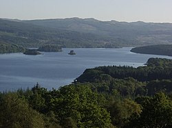
Loch Awe (Gaelic: Loch Obha) is a large freshwater loch in the heart of Argyllshire, a great gash through the mountains of Lorn, 22 miles long. It has also given its name to a village on its banks, variously known as Loch Awe, or Lochawe. There are islands within the loch, of which the most famous a but a little isle, Innis Chonnell, on which stand the ruins of the old fighting stronghold of the Chiefs of the Clan Campbell. More peaceful islands in the loch are Inishail and Innis Chonan.
The loch
This is the third largest freshwater loch in the Highlands, with a surface area of 15 square miles. It is the longest freshwater loch, measuring 25 miles from end to end with an average width of 0.6 mile.
The loch runs approximately southwest to northeast for about 22 miles, from close to the coast out into the mountains. It is isolated from the sea, but 5 miles to the north is Loch Etive, a sea-loch 18 miles long, cutting deep into the land, indeed Loch Awe is roughly parallel to two sea lochs, Loch Etive and Loch Fyne to north and to south. In shape, Loch Awe is of long, gentle curves in a single sweep until its northern end, where an arm leades off at a right angle north-westward in the Pass of Brander, from which arm flows the River Awe.
Loch Awe is fed by many streams, the largest feeders being the River Orchy and the Kames River. The loch drains to the sea by way of the River Awe, which runs down into Loch Etive, running westward from its northern end and thus into the Atlantic Ocean.
At the narrowest section of the loch are North Port (Taychreggan Hotel) and South Port (Portsonachan Hotel). Once used by cattle drovers, a ferry ran between these shores to facilitate crossing to markets beyond. A more modern communication, the Transatlantic Cable, runs through the village of Kilchrenan, laid across the loch at this point in 1955.
Hydroelectric schemes
Loch Awe is the site of two hydroelectric projects. One is a conventional turbine power station, created by damming the River Awe in the Pass of Brander, feeding the water through underground pipes, and generating electricity as it flows into Loch Etive.
The second plant is a more unusual pumped storage project, using a man-made loch in the hills above the loch; water is pumped up during times of surplus power, and used to power generators at times of peak demand. This project is known as Cruachan Dam from the name of the hill above, and has a visitor centre, which includes tours into the heart of the mountain.
Tourism

Loch Awe is renowned for its trout fishing. Salmon pass through the loch, coming past the barrage in the River Awe and continuing into the River Orchy. Loch Awe contains several ruined castles on islands, and at the northern end has one of the most photographed castles in the Highlands, Kilchurn Castle, which in summer may be visited by a short boat trip or by a half mile walk from a small car park just after the bridge over the River Orchy. Saint Conan's Kirk and Chapel of St Fyndoca are located in Loch Awe.
History
One of the oldest Argyll clans, the Macarthurs, owned lands around Loch Awe which was populated in close proximity with MacGregors, Campbells and Stewarts.
Clan Macarthur artefacts, including the four-poster state bed, are held at Inveraray Castle.[1]
It was from Loch Awe and surrounding area that Clan Campbell established itself as a powerful family. In 1308, Robert the Bruce defeated the Clan MacDougall at the Battle of the Pass of Brander downstream from the loch.
Environs

The A85 road and the West Highland Line run along the northern bank of the loch, and the A819 follows the south-east bank for a short distance up to the village of Cladich. From there the single-track B840 finds the way through the mountains by following the south bank of the loch to Ford (and then joining the A816 a short distance north of Kilmartin). On the north shore an unclassified single-track road runs the full length from the Taynuilt to Ford.
At the northern tip of the Loch, a railway station was opened in 1880 when the Callander and Oban Railway passed that way, and a large luxury hotel was created (Loch Awe Hotel, 1871). There is also the Tight Line Bar which used to be the coach-house for the hotel. A village has grown up around the hotel, essentially running along the single strip defined by the A85 road. A steamer service used to operate on the loch from the pier just below the hotel, stopping at Portsonachan, Taycreggan, Eredine and Ford. The village now includes St Conan’s Kirk, one of the most interesting pieces of Church architecture in Scotland. Confusingly, while the railway station is called Loch Awe, the village is contracted to Lochawe.
Outside links
| ("Wikimedia Commons" has material about Loch Awe) |
- Map: 56°17’53"N, 5°14’6"W
- The Loch Awe community web site
- The Tight Line website
- Fishing-Argyll web site
- Alexander Carrick, sculptor of war memorial and St. Conan's Kirk
References
- ↑ "First Floor". Inveraray Castle. http://www.inveraray-castle.com/inveraray-castle-first-floor.html.
