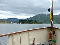
Eilean Dubh, Kyles of Bute: Difference between revisions
Created page with "thumb|right|250px|Eilean Dubh photographed from the PS ''Waverley'' {{county|Argyll}} '''Eilean Dubh''', sometimes known as '''Glen Caladh Island''', ..." |
No edit summary |
||
| Line 1: | Line 1: | ||
[[File: | [[File:Caladh Harbour, Kyles of Bute - geograph.org.uk - 7111.jpg|right|thumb|300px|Caladh Harbour]] | ||
{{county|Argyll}} | {{county|Argyll}} | ||
'''Eilean Dubh''', sometimes known as '''Glen Caladh Island''', is a wee isle lying just off the [[Cowal]] peninsula in the [[Kyles of Bute]]. It belongs to [[Argyllshire]]. The island is around 350 yards along its longest length and rises to a height of 62 feet above sea level. It is almost entirely covered by woodland. | '''Eilean Dubh''', sometimes known as '''Glen Caladh Island''', is a wee isle lying just off the [[Cowal]] peninsula in the [[Kyles of Bute]]. It belongs to [[Argyllshire]]. The island is around 350 yards along its longest length and rises to a height of 62 feet above sea level. It is almost entirely covered by woodland. | ||
The name ''Eilean Dubh'' is possibly the most common of all island names off the coast of Scotland; it means | The name ''Eilean Dubh'' is possibly the most common of all island names off the coast of Scotland; it means "Black Island". | ||
Although Eilean Dubh is uninhabited the islands owners, the Ingham Clarks, have their family graveyard here. There is also a light to aid navigation at the northern tip of the island. | Although Eilean Dubh is uninhabited the islands owners, the Ingham Clarks, have their family graveyard here. There is also a light to aid navigation at the northern tip of the island. | ||
The island forms the idyllic, "An Caladh/An Cala" (Gaelic for "harbour") on the Cowal coastline | The island forms, with the coast of Cowal, the idyllic, "An Caladh/An Cala" (Gaelic for "harbour") on the Cowal coastline. An Caladh was used as a location in BBC television's dramatisation of the Para Handy tales. | ||
[[Eilean Dearg, Loch Ruel|Eilean Dearg]] lies to the north and the [[Burnt Islands]] lie just to the east. | [[Eilean Dearg, Loch Ruel|Eilean Dearg]] lies to the north and the [[Burnt Islands]] lie just to the east. | ||
| Line 14: | Line 14: | ||
*Wikishire map: {{wmap|55.93289|-5.19373}} | *Wikishire map: {{wmap|55.93289|-5.19373}} | ||
*Streetmap: {{map|NS006757}} | *Streetmap: {{map|NS006757}} | ||
[[File:Eilean Dubh.jpg|left|thumb|200px|Eilean Dubh photographed from the PS ''Waverley'']] | |||
[[Category:Islands of Argyllshire]] | [[Category:Islands of Argyllshire]] | ||
Revision as of 20:05, 10 February 2015

Eilean Dubh, sometimes known as Glen Caladh Island, is a wee isle lying just off the Cowal peninsula in the Kyles of Bute. It belongs to Argyllshire. The island is around 350 yards along its longest length and rises to a height of 62 feet above sea level. It is almost entirely covered by woodland.
The name Eilean Dubh is possibly the most common of all island names off the coast of Scotland; it means "Black Island".
Although Eilean Dubh is uninhabited the islands owners, the Ingham Clarks, have their family graveyard here. There is also a light to aid navigation at the northern tip of the island.
The island forms, with the coast of Cowal, the idyllic, "An Caladh/An Cala" (Gaelic for "harbour") on the Cowal coastline. An Caladh was used as a location in BBC television's dramatisation of the Para Handy tales.
Eilean Dearg lies to the north and the Burnt Islands lie just to the east.
Outside links
- Wikishire map: 55°55’58"N, 5°11’37"W
- Streetmap: NS006757
