Llandrillo: Difference between revisions
Jump to navigation
Jump to search
Created page with "{{Infobox town |name=Llandrillo |welsh=Rhiwabon |county=Merionethshire |picture=Western approach to the sharp bend in Llandrillo's High Street - geograph.org.uk - 472186.jpg |..." |
No edit summary |
||
| Line 1: | Line 1: | ||
{{Infobox town | {{Infobox town | ||
|name=Llandrillo | |name=Llandrillo | ||
|welsh= | |welsh= | ||
|county=Merionethshire | |county=Merionethshire | ||
|picture=Western approach to the sharp bend in Llandrillo's High Street - geograph.org.uk - 472186.jpg | |picture=Western approach to the sharp bend in Llandrillo's High Street - geograph.org.uk - 472186.jpg | ||
Latest revision as of 11:39, 23 October 2014
| Llandrillo | |
| Merionethshire | |
|---|---|

| |
| Location | |
| Grid reference: | SH0337 |
| Location: | 52°55’23"N, 3°26’17"W |
| Data | |
| Population: | 580 (2011) |
| Post town: | Corwen |
| Postcode: | LL21 |
| Dialling code: | 01490 |
| Local Government | |
| Council: | Denbighshire |
| Parliamentary constituency: |
Clwyd South |
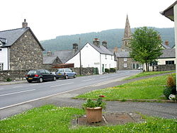
Llandrillo (or, in full, Llandrillo yn Edeirnion) is a small village and parish in the Edeirnion area of Merionethshire, on the B4401 road between Bala and Corwen.
It is named after Saint Trillo who came from Brittany with other missionaries and who founded Llandrillo church on a mound next to the Ceidiog stream close to its confluence with the River Dee.
Outside links

This Merionethshire article is a stub: help to improve Wikishire by building it up.