Newtown, Montgomeryshire: Difference between revisions
Created page with '{{Infobox town |name=Newtown |welsh=Y Drenewydd |county=Montgomeryshire |picture=Newtown, Wales.jpg |picture caption=Newtown town centre |post town=Newtown |postcode=SY16 |dialli…' |
No edit summary |
||
| Line 18: | Line 18: | ||
==Geography== | ==Geography== | ||
The most central populated town in Wales, Newtown sits deep in Montgomeryshire, some 10 miles from the boundary with Shropshire. It was built within a narrow valley, restricting development north and south of the town. Newtown is surrounded by small villages often referenced as the Newtown area. If Newtown were to include all its postal villages, the town's population would approach 20,000. The villages with Newtown as their post town include [[Aberhafesp]], [[Adfa, Montgomeryshire|Adfa]], [[Bettws Cedewain]], [[Bwlch-y-ffridd]], [[Cefn-gwyn]], [[Dolfor]], [[Glanmule, Montgomeryshire|Glanmule]], [[Kerry, | The most central populated town in Wales, Newtown sits deep in Montgomeryshire, some 10 miles from the boundary with Shropshire. It was built within a narrow valley, restricting development north and south of the town. Newtown is surrounded by small villages often referenced as the Newtown area. If Newtown were to include all its postal villages, the town's population would approach 20,000. The villages with Newtown as their post town include [[Aberhafesp]], [[Adfa, Montgomeryshire|Adfa]], [[Bettws Cedewain]], [[Bwlch-y-ffridd]], [[Cefn-gwyn]], [[Dolfor]], [[Glanmule, Montgomeryshire|Glanmule]], [[Kerry, Montgomeryshire|Kerry]], [[Llanllwchaiarn]], [[Llanwyddelan]], [[Mochdre, Montgomeryshire|Mochdre]], [[New Mills, Montgomeryshire|New Mills]], [[Pentre, Montgomeryshire|Pentre]], [[Rhydlydan]], [[Sarn, Montgomeryshire|Sarn]] and [[Tregynon]]. | ||
==History== | ==History== | ||
Latest revision as of 17:33, 16 October 2014
| Newtown Welsh: Y Drenewydd | |
| Montgomeryshire | |
|---|---|
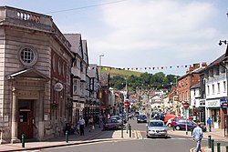
 Newtown town centre | |
| Location | |
| Grid reference: | SO115915 |
| Location: | 52°30’48"N, 3°18’51"W |
| Data | |
| Population: | 12,783 |
| Post town: | Newtown |
| Postcode: | SY16 |
| Dialling code: | 01686 6 |
| Local Government | |
| Council: | Powys |
| Parliamentary constituency: |
Montgomeryshire |
Newtown is the largest town in Montgomeryshire. Lying on the River Severn, the town is best known as the birthplace of the industrialist Robert Owen in 1771[1] with his former house now being a museum. Newtown is also the home of Theatr Hafren and Oriel Davies Gallery, a major public gallery of Wales, which shows national and international contemporary art and craft.
Geography
The most central populated town in Wales, Newtown sits deep in Montgomeryshire, some 10 miles from the boundary with Shropshire. It was built within a narrow valley, restricting development north and south of the town. Newtown is surrounded by small villages often referenced as the Newtown area. If Newtown were to include all its postal villages, the town's population would approach 20,000. The villages with Newtown as their post town include Aberhafesp, Adfa, Bettws Cedewain, Bwlch-y-ffridd, Cefn-gwyn, Dolfor, Glanmule, Kerry, Llanllwchaiarn, Llanwyddelan, Mochdre, New Mills, Pentre, Rhydlydan, Sarn and Tregynon.
History
Early period
Newtown was founded at the end of the thirteenth century when Edward I of England commissioned Roger de Montgomerie to construct a centre for the hamlet of Llanfair-yng-Nghedewain. It was situated near the ford on the River Severn, below the Long Bridge and around the church of St Mary in Cedewain. This gave Newtown its original Welsh name.[2] The foundation is intimately connected to the fate of Llywelyn ap Gruffudd, Prince of Wales, whose new administrative centre at Dolforwyn Castle near Abermule so alarmed Edward I that it was besieged. He seized Llywelyn's lands and granted them to the Mortimers. They transferred the administration of the cantref of Cedewain and the commote of Ceri from Dolforwyn Castle to the new settlement at Newtown.
Later period
The town grew in the eighteenth and nineteenth centuries around the textile and flannel industry, stimulated by the completion of the Montgomeryshire Canal. In 1838, the town saw Wales' first Chartist demonstration.
The town was designated as a "new town" in 1967.[3] It has seen a large population growth as companies and people have settled, changing the rural market town character. Today it is the largest town in Mid Wales. Newtown hosted the National Eisteddfod in 1965.
Buildings and monuments
Built by Pryce Jones, the Royal Welsh Warehouse remains the tallest building in Newtown. The two towering structures housed the world's first mail order service depot.
Bear Lanes, the town's main shopping centre, sports a Tudor-style entrance. The building was once a hotel, The Bear, which contributes to the mall's appearance today.
A statue of Robert Owen was erected in 1956 in a small park off Shortbridge Street and Gas street. A replica statue was later built in Manchester.
The Free Library building, designed by the architect Frank Shayler of Shrewsbury, was built in 1902.
Museums and Galleries
- Robert Owen Museum
- Textile Museum
- W H Smith Museum
- Oriel Davies Gallery, largest and most significant visual arts venue in the region. Free admission.
Theatr Hafren
Theatr Hafren is one of the most popular theatres in Mid Wales. With a 555-seat capacity, the venue has attracted many nationally famous performers and allows drama students to use its facilities.
Footnotes
- ↑ [1] Robert Owen Biography
- ↑ Jones, D "Old town, Newtown", in About Wales, November 2007. Civic Trust for Wales.
- ↑ London Gazette: no. 44482. p. 14168. 28 December 1967. Retrieved 2007-10-30.
Outside links
- Town website
- Newtownweather.co.uk - Newtown weather
- Newtown-MC.co.uk Newtown And District Automobile Club Ltd
- Robert Owen Museum
- Newtown Textile Museum
- Oriel Davies Gallery