Houghton Regis: Difference between revisions
Created page with '{{Infobox town |name=Houghton Regis |county=Bedfordshire |picture=Houghton Regis.jpg |picture caption=All Saints Church |os grid ref= |latitude=51.9039 |longitude=-0.5247 |popul…' |
No edit summary |
||
| Line 20: | Line 20: | ||
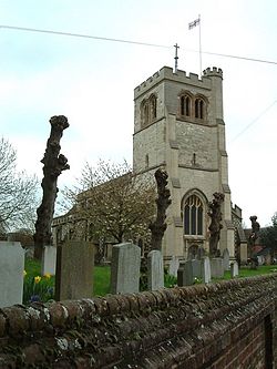
Remnants of the town's past are still apparent with, for example, the fifteenth century Parish Church of All Saints (formerly St Michaels) with an excellent example of a Norman tower<ref>[http://www.houghtonregis.com/About_Us.html Houghton Regis – About Us]</ref> and the former Squire's residence of Houghton Hall, built in the eighteenth century. | Remnants of the town's past are still apparent with, for example, the fifteenth century Parish Church of All Saints (formerly St Michaels) with an excellent example of a Norman tower<ref>[http://www.houghtonregis.com/About_Us.html Houghton Regis – About Us]</ref> and the former Squire's residence of Houghton Hall, built in the eighteenth century. | ||
==Parish church== | |||
The parish church is All Saints, which was formerly dedicated to St Michael. Its Norman tower is a fine surviving example of the type. It also has a Norman font (of 'Aylesbury' type) and an impressive bell tower. | |||
==History== | ==History== | ||
Latest revision as of 22:08, 27 July 2014
| Houghton Regis | |
| Bedfordshire | |
|---|---|
 All Saints Church | |
| Location | |
| Location: | 51°54’14"N, -0°31’29"W |
| Data | |
| Population: | 16,950 (est.) |
| Post town: | Dunstable |
| Postcode: | LU5 |
| Dialling code: | 01582 |
| Local Government | |
| Council: | Central Bedfordshire |
| Parliamentary constituency: |
South West Bedfordshire |
Houghton Regis is a small town in Bedfordshire, contiguous with the larger town of Dunstable to the south. Its parish council provides certain sports and open space amenities and includes the ancient hamlets of Bidwell, Thorn, and Sewell. Houghton Regis, along with its near neighbours of Dunstable and Luton form the informal 'Luton/Dunstable Urban Area', with a population over 230,000.
Bordered by the Chiltern Hills, the town was once a small village that had its character changed when it was earmarked for a massive "London overspill" estate in the 1950s and 60s. The only remains of the manors, rectory land and cottage demesnes around the small village centre are names such as Tithe Farm Road. An indication of the planners' attempts to make the London migrants feel at home is the naming of the local estate roads after London landmarks; Chelsea Gardens is an example.
Remnants of the town's past are still apparent with, for example, the fifteenth century Parish Church of All Saints (formerly St Michaels) with an excellent example of a Norman tower[1] and the former Squire's residence of Houghton Hall, built in the eighteenth century.
Parish church
The parish church is All Saints, which was formerly dedicated to St Michael. Its Norman tower is a fine surviving example of the type. It also has a Norman font (of 'Aylesbury' type) and an impressive bell tower.
History
Houghton Regis is considerably older than Dunstable, and it is mentioned in the Domesday Book in which it is called 'Houstone'.[2] At the time of the Domesday Survey a great part of what is now Dunstable was included in Houghton parish. When Henry I founded Dunstable he gave in compensation to the men of Houghton a wood called Buckwood.[3] At that time it paid in tax the large amount of three pounds by weight and twenty shillings of blanch silver (to the King) and one ounce of gold for the Sheriff.[4] Timeline for Houghton Regis.
The men of Houghton claimed to be exempt from tolls in Dunstable market.[5] The inhabitants of Houghton Regis were for long employed in straw-plaiting. In 1689 they and those of neighbouring villages petitioned against the Bill that made it compulsory to wear woollen hats, pointing out that the straw-plaiters would be ruined and that the farmers also would suffer, as they now obtained good prices for their straw, and English wool not being suitable for hatmaking, they would not be in any way compensated.[3]
Economy
Between the town centre and Dunstable this area has the Townsend Industrial Estate, built on the former farm of the same name.
Between the late 1960s and the early 1970s, many of the high street shops were demolished along with a church to make way for industrial units, many of which have since been demolished themselves. The main shop in town was the Wavy Line store, which has since been used as a motorbike and car showroom.
A fish and chip shop was at the entrance to what is now the access road into the Co-op Store; the current fish and chip shop was a sex shop in the 1960s boasting a working model railway in the window. This was adjacent to a now demolished church (in front of the existing graveyard) and opposite a hardware shop and wood store.
Big Society
Houghton Regis Town Council organise a Carnival every summer on the Village Green. A cycle route runs through the town. The Greenway and the route through Dunstable and Houghton Regis forms part of National Route 6 of the National Cycle Network, which provides walking and cycling routes between Milton Keynes, Luton and London.
Outside links
References
- ↑ Houghton Regis – About Us
- ↑ Domesday Book: A Complete Translation. London: Penguin, 2003. ISBN 0-14-143994-7 p.1361
- ↑ 3.0 3.1 http://www.british-history.ac.uk/report.aspx?compid=42453
- ↑ Domesday Book: A Complete Translation. London: Penguin, 2003. ISBN 0-14-143994-7 p.563
- ↑ Ann. Mon. (Rolls Ser.), iii, 377