Whetstone: Difference between revisions
Jump to navigation
Jump to search
Created page with '{{Infobox town | name = Whetstone | county = Middlesex | picture = Totteridge_%26_Whetstone_stn_building.JPG | picture caption = Totteridge & Whetstone tube station | os grid ref…' |
No edit summary |
||
| Line 7: | Line 7: | ||
| latitude = 51.6260 | | latitude = 51.6260 | ||
| longitude = -0.1715 | | longitude = -0.1715 | ||
| post town = | | post town = London | ||
| postcode = N20 | | postcode = N20 | ||
| dialling code = 020 | | dialling code = 020 | ||
Revision as of 18:42, 9 November 2013
| Whetstone | |
| Middlesex | |
|---|---|
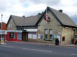
 Totteridge & Whetstone tube station | |
| Location | |
| Grid reference: | TQ195925 |
| Location: | 51°37’34"N, 0°10’17"W |
| Data | |
| Post town: | London |
| Postcode: | N20 |
| Dialling code: | 020 |
| Local Government | |
| Council: | Barnet |
| Parliamentary constituency: |
Chipping Barnet |
Whetstone is a village in northern Middlesex. It is located to the east of Totteridge in Hertfordshire, separated by Dollis Brook which marks the boundary between the counties. Totteridge & Whetstone tube station is located in Whetstone.

This Middlesex article is a stub: help to improve Wikishire by building it up.