An Coileachan: Difference between revisions
Created page with '{{Infobox hill |name=An Coileachan |county=Ross-shire |range=Fannichs |picture=River Grudie - geograph.org.uk - 1576572.jpg |picture caption=An Coileachan across the River Grudie…' |
mNo edit summary |
||
| Line 20: | Line 20: | ||
An Coileachan can conveniently be climbed along with others of the Fannichs' mountains and tops, in particular with nearby [[Meall Gorm]] or on a circular route including a descent to the shores of the splendid but isolated Loch Fannich. | An Coileachan can conveniently be climbed along with others of the Fannichs' mountains and tops, in particular with nearby [[Meall Gorm]] or on a circular route including a descent to the shores of the splendid but isolated Loch Fannich. | ||
{{Munro}} | |||
Revision as of 21:50, 18 September 2013
| An Coileachan | |||
| Ross-shire | |||
|---|---|---|---|
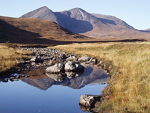
 An Coileachan across the River Grudie | |||
| Range: | Fannichs | ||
An Coileachan is a mountain in the Fannichs group, the easternmost of the nine munros of the Fannichs, mountains over 3,000 feet.
The summit of An Coileachan is in Ross-shire, though its western slopes are in the detached part of Cromartyshire which latter shire takes in most of the highest mountains of the range.
The mountain rises up to the south of Loch Gorm, a steep-sided dome.
Ascent

An Coileachan might be approached on the track from the shore of Loch Fannich, which is close by. However the usual approach from the north is a long trail across the bogs and through the burns, for the main road, the A835, is to the north.
An Coileachan can conveniently be climbed along with others of the Fannichs' mountains and tops, in particular with nearby Meall Gorm or on a circular route including a descent to the shores of the splendid but isolated Loch Fannich.