Hounslow: Difference between revisions
Jump to navigation
Jump to search
Created page with '{{Infobox town | name = Hounslow | county = Middlesex | picture=Hounslow_High_Street.1.JPG | picture caption=Hounslow High Street | os grid ref= TQ145755 | latitude = 51.4668 | l…' |
No edit summary |
||
| Line 13: | Line 13: | ||
| constituency= Brentford and Isleworth | | constituency= Brentford and Isleworth | ||
}} | }} | ||
'''Hounslow''' is a town in [[Middlesex]] within the Greater London conurbation. It is located between [[Isleworth]] to the east, [[Feltham]] to the west, [[Whitton] to the south and [[Heston]] to the north. | '''Hounslow''' is a town in [[Middlesex]] within the Greater London conurbation. It is located between [[Isleworth]] to the east, [[Feltham]] to the west, [[Whitton]] to the south and [[Heston]] to the north. | ||
{{stub}} | {{stub}} | ||
Revision as of 17:10, 26 July 2013
| Hounslow | |
| Middlesex | |
|---|---|
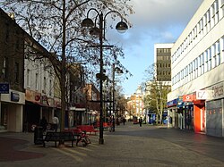
 Hounslow High Street | |
| Location | |
| Grid reference: | TQ145755 |
| Location: | 51°28’0"N, 0°21’3"W |
| Data | |
| Post town: | Hounslow |
| Postcode: | TW3 |
| Dialling code: | 020 |
| Local Government | |
| Council: | Hounslow |
| Parliamentary constituency: |
Brentford and Isleworth |
Hounslow is a town in Middlesex within the Greater London conurbation. It is located between Isleworth to the east, Feltham to the west, Whitton to the south and Heston to the north.

This Middlesex article is a stub: help to improve Wikishire by building it up.