Northolt: Difference between revisions
Jump to navigation
Jump to search
Created page with '{{Infobox town | name = Northolt | county = Middlesex | picture = Northala_Fields_-_main_mound_-_geograph.org.uk_-_1018934.jpg | picture caption = Northala Fields | latitude = 51…' |
No edit summary |
||
| Line 14: | Line 14: | ||
}} | }} | ||
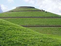
'''Northolt''' is a town in [[Middlesex]], located between [[Ruislip]] to the west, [[Greenford] to the east, [[Harow]] to the north and [[Southall]] to the south. It is home to Northala Fields, a park featuring four arfiticial hills constructed using rubble from the demolished Wembley Stadium. | '''Northolt''' is a town in [[Middlesex]], located between [[Ruislip]] to the west, [[Greenford] to the east, [[Harow]] to the north and [[Southall]] to the south. It is home to Northala Fields, a park featuring four arfiticial hills constructed using rubble from the demolished Wembley Stadium. | ||
{{stub}} | |||
Revision as of 15:41, 26 July 2013
| Northolt | |
| Middlesex | |
|---|---|
 Northala Fields | |
| Location | |
| Grid reference: | TQ135845 |
| Location: | 51°32’49"N, 0°21’43"W |
| Data | |
| Post town: | Northolt |
| Postcode: | UB5 |
| Dialling code: | 020 |
| Local Government | |
| Council: | Ealing |
| Parliamentary constituency: |
Ealing North |
Northolt is a town in Middlesex, located between Ruislip to the west, [[Greenford] to the east, Harow to the north and Southall to the south. It is home to Northala Fields, a park featuring four arfiticial hills constructed using rubble from the demolished Wembley Stadium.

This Middlesex article is a stub: help to improve Wikishire by building it up.