Horseshoe Island, Graham Land: Difference between revisions
Created page with ':''Not to be confused with Horseshoe Island, Bermuda'' {{Infobox island |name=Horseshoe Island |territory=British Antarctic Territory |picture=Base Y (Marguerite Bay).jpg |pi…' |
mNo edit summary |
||
| Line 10: | Line 10: | ||
'''Horseshoe Island''' is a small rocky island of the [[British Antarctic Territory]], in Bourgeois Fjord in Marguerite Bay off western [[Graham Land]]. Here stands Horseshoe Base, or "Base Y (Marguerite Bay)", a British scientific base closed in 1960. | '''Horseshoe Island''' is a small rocky island of the [[British Antarctic Territory]], in Bourgeois Fjord in Marguerite Bay off western [[Graham Land]]. Here stands Horseshoe Base, or "Base Y (Marguerite Bay)", a British scientific base closed in 1960. | ||
The island is 6.5 nautical miles long and 3 nautical miles and it sits squarely across the entrance to [[Square Bay]], along the west coast of [[Graham Land]]. It was discovered and named by the British Grahamland Expedition under Rymill who mapped this area by land and from the air in 1936–37. Its name is indicative of the crescentic alignment of the peaks 2,000 - 3,000 feet high which give a comparable shape to the island. | The island is 6.5 nautical miles long and 3 nautical miles and it sits squarely across the entrance to [[Square Bay]], along the west coast of [[Graham Land]]. It was discovered and named by the British Grahamland Expedition under Rymill who mapped this area by land and from the air in 1936–37. Its name is indicative of the crescentic alignment of the peaks 2,000 - 3,000 feet high which give a comparable shape to the island. | ||
The island wildlife is that which is familiar on these bleak coasts; kelp gulls (''Larus dominicanus'') breed here as do occasional brown skuas (''Catharacta antarctica lonnbergi''). There are 29 recorded species of lichen on the island and 15 species of moss. | The island wildlife is that which is familiar on these bleak coasts; kelp gulls (''Larus dominicanus'') breed here as do occasional brown skuas (''Catharacta antarctica lonnbergi''). There are 29 recorded species of lichen on the island and 15 species of moss. | ||
Revision as of 20:55, 29 March 2013
- Not to be confused with Horseshoe Island, Bermuda
| Horseshoe Island | |
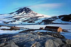
 Base Y (Marguerite Bay) and Mount Searle | |
|---|---|
| Location | |
| Location: | 67°48'S 67°18'W |
| Data | |
Horseshoe Island is a small rocky island of the British Antarctic Territory, in Bourgeois Fjord in Marguerite Bay off western Graham Land. Here stands Horseshoe Base, or "Base Y (Marguerite Bay)", a British scientific base closed in 1960.
The island is 6.5 nautical miles long and 3 nautical miles and it sits squarely across the entrance to Square Bay, along the west coast of Graham Land. It was discovered and named by the British Grahamland Expedition under Rymill who mapped this area by land and from the air in 1936–37. Its name is indicative of the crescentic alignment of the peaks 2,000 - 3,000 feet high which give a comparable shape to the island.
The island wildlife is that which is familiar on these bleak coasts; kelp gulls (Larus dominicanus) breed here as do occasional brown skuas (Catharacta antarctica lonnbergi). There are 29 recorded species of lichen on the island and 15 species of moss.
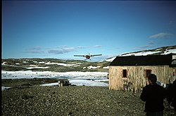
The preferred landing site for the island is in Sally Cove to the south of the hut of Horseshoe Base.
Horseshoe Base
| Horseshoe Base | |
|
| |
|---|---|

| |
| Information |
Horseshoe 'Base Y' on Horseshoe Island sits on a small peninsula at the north-western end of the island overlooking Sally Cove. The base was established in March 1955 and closed in August 1960. It re-opened for a 4 month period in 1969. The scientific research carried out at the station included topographic survey, geology and meteorology. Extensive survey trips, often covering hundreds of miles and lasting several months, were undertaken from the station using dog sledges.
The base's relatively short lifetime means that it has preserved a snapshot image of the scientific equipment and techniques of the late 1950s, not to mention the British way of doing things, which is all of considerable interest.
In addition to the base building, there is also a balloon shed, pup pens, an emergency store, two pram dinghies and a winch.
Blaiklock, a refuge hut, stands nearby and is considered an integral part of the site.
Base Y, Horseshoe Island was designated HSM No. 63 in 1995. The UK Antarctic Heritage Trust became involved later. . An estimated 10,000 artefacts are to be found on site
Outside links
| ("Wikimedia Commons" has material about Horseshoe Island, Graham Land) |
- Gazetteer and Map of The British Antarctic Territory: Horseshoe Island
- Horseshoe Visitor Guide – Antarctic Treaty
- Horseshoe blog
References
Coordinates: 67°51′S 67°12′W / 67.85°S 67.2°W

