Moelwynion: Difference between revisions
Jump to navigation
Jump to search
Created page with 'Category:Mountains and hills of Merionethshire' |
No edit summary |
||
| Line 1: | Line 1: | ||
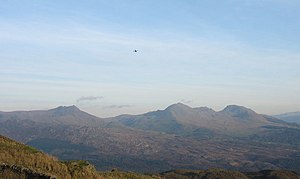
[[File:Moelwynion, geograph.jpg|right|thumb|300px|'''Moelwynion''': (L to R) Cnicht, Moelwyn Mawr, Craigysgafn, Moelwyn Bach]] | |||
The '''Moelwynion''', sometimes Anglicised to '''the Moelwyns''', are a group of mountains in the north of [[Merionethshire]], immediately to the south of the [[Snowdonia]] group. They rise to their greatest height with [[Moel Siabod]], at 2,861 feet above sea level. | |||
The name ''Moelwynion'' is plural in Welsh, and is taken from two of the tallest mountains in the group; Moelwyn Mawr (''great white hill'') and Moelwyn Bach (''little white hill''). | |||
The group extends from northeast of [[Porthmadog]] out to [[Moel Siabod]], the highest of the group. | |||
The group includes the following mountains: | |||
*[[Moel Siabod]] | |||
*[[Moelwyn Mawr]] | |||
*[[Moelwyn Bach]] | |||
*[[Allt-fawr]] | |||
*[[Cnicht]] | |||
*[[Craigysgafn]] | |||
*[[Cnicht North Top]] | |||
*[[Moel Druman]] | |||
*[[Ysgafell Wen]] | |||
*[[Ysgafell Wen North Top]] | |||
*[[Manod Mawr]] | |||
*[[Manod Mawr North Top]] | |||
*[[Ysgafell Wen Far North Top]] | |||
*[[Moel-yr-hydd]] | |||
*[[Moelwyn Mawr North Ridge Top]] | |||
*[[Moel Penamnen]] | |||
*[[Moel Meirch]] | |||
{{Coord|53.036|-3.980|dim:20000_region:GB|display=title}} | |||
==External links== | |||
* [http://www.walkeryri.org.uk/?cat=16 Walking Routes in the Moelwynion] | |||
{{Catself}} | |||
[[Category:Mountains and hills of Merionethshire]] | [[Category:Mountains and hills of Merionethshire]] | ||
Revision as of 19:57, 1 February 2013

The Moelwynion, sometimes Anglicised to the Moelwyns, are a group of mountains in the north of Merionethshire, immediately to the south of the Snowdonia group. They rise to their greatest height with Moel Siabod, at 2,861 feet above sea level.
The name Moelwynion is plural in Welsh, and is taken from two of the tallest mountains in the group; Moelwyn Mawr (great white hill) and Moelwyn Bach (little white hill).
The group extends from northeast of Porthmadog out to Moel Siabod, the highest of the group.
The group includes the following mountains:
- Moel Siabod
- Moelwyn Mawr
- Moelwyn Bach
- Allt-fawr
- Cnicht
- Craigysgafn
- Cnicht North Top
- Moel Druman
- Ysgafell Wen
- Ysgafell Wen North Top
- Manod Mawr
- Manod Mawr North Top
- Ysgafell Wen Far North Top
- Moel-yr-hydd
- Moelwyn Mawr North Ridge Top
- Moel Penamnen
- Moel Meirch
Coordinates: 53°02′10″N 3°58′48″W / 53.036°N 3.980°W