Barren Island: Difference between revisions
Jump to navigation
Jump to search
Created page with '{{Infobox island |name=Barren Island |territory=Falkland Islands |picture= |map= |map caption= |latitude=-52.3758 |longitude=-59.7 |area=2,840 acres |highest height= |population=…' |
mNo edit summary |
||
| Line 3: | Line 3: | ||
|territory=Falkland Islands | |territory=Falkland Islands | ||
|picture= | |picture= | ||
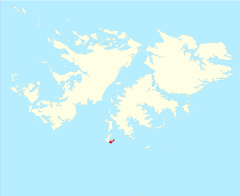
|map= | |map=Falkland Islands - Barren Island.svg | ||
|map caption= | |map caption= | ||
|latitude=-52.3758 | |latitude=-52.3758 | ||
Latest revision as of 09:16, 17 August 2012
| Barren Island | |
| Location | |
| Location: | 52°22’33"S, 59°42’0"W |
| Area: | 2,840 acres |
| Data | |
Barren Island is one of the Falkland Islands, lying south west of East Falkland and south east of George Island. It is separated from Lafonia by Eagle Passage. Its total area is 4½ square miles.
It, together with George Island is run as a sheep farm and the tourism there is well run. The island is free of rats, and this is important for the survival of small songbirds.[1]
There are two listed buildings on Barren Island, a house and a woolshed.[2]
References
- ↑ PART II: Falkland Islands Important Bird Areas - Speedwell Island Group
- ↑ "Falkland Islands Information Web Portal". Buildings and Structures in the Falkland Islands designated as being of Architectural or Historic Interest. http://www.falklands.info/background/listedb.html. Retrieved 2008-07-08.
