Castleton, Monmouthshire: Difference between revisions
mNo edit summary |
Tredegar House is not in Castleton |
||
| Line 28: | Line 28: | ||
==Outside links== | ==Outside links== | ||
*{{Geograph|6682782}} | *{{Geograph|6682782}} | ||
==References== | ==References== | ||
{{reflist}} | {{reflist}} | ||
Revision as of 17:36, 15 August 2012
| Castleton Welsh: Cas-bach | |
| Monmouthshire | |
|---|---|
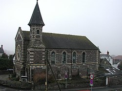
 Castleton Baptist Church | |
| Location | |
| Grid reference: | ST253835 |
| Location: | 51°32’44"N, 3°4’41"W |
| Data | |
| Post town: | Cardiff |
| Postcode: | CF3 |
| Dialling code: | 01633 |
| Local Government | |
| Council: | Newport |
| Parliamentary constituency: |
Newport West |
Castleton is a small village in Monmouthshire, in the southwest of the county, perched between Newport to the east and Cardiff to the west. St Mellons, a Monmouthshire town that is now a Cardiff suburb, is the closest town.
The A48 dual carriageway is the main road through the village and to a passer-by Castleton may appear just as the few cottages along the road and an inn, with yards and farms beside, though more of Castleton is hidden away south of the main road.
About the village

The village has a pub / restaurant, the Coach and Horses, on the A48.
Castleton also has a large, prominent Baptist chapel across the road from the pub. It was at the Castleton Baptist Association meeting in 1816 that it was resolved to build the first Welsh Baptist Chapel in Newport, and the land then acquired in Charles Street, with the help of a bequest from John Williams, a Newport tailor.[1]