Burnham Green: Difference between revisions
Jump to navigation
Jump to search
No edit summary |
No edit summary |
||
| Line 2: | Line 2: | ||
|name=Burnham Green | |name=Burnham Green | ||
|county=Hertfordshire | |county=Hertfordshire | ||
|picture=Burnham | |picture=The White Horse, Burnham Green - geograph.org.uk - 150853.jpg | ||
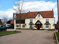
|picture caption= | |picture caption=The White Horse, Burnham Green | ||
|os grid ref=TL262165 | |os grid ref=TL262165 | ||
|latitude=51.832941 | |latitude=51.832941 | ||
| Line 9: | Line 9: | ||
|population= | |population= | ||
|census year= | |census year= | ||
|post town= | |post town=Welwyn | ||
|postcode=AL6 | |postcode=AL6 | ||
|dialling code | |dialling code=01438 | ||
|LG district= | |LG district= | ||
|constituency= | |constituency= | ||
Latest revision as of 11:27, 26 May 2016
| Burnham Green | |
| Hertfordshire | |
|---|---|
 The White Horse, Burnham Green | |
| Location | |
| Grid reference: | TL262165 |
| Location: | 51°49’59"N, 0°10’9"W |
| Data | |
| Post town: | Welwyn |
| Postcode: | AL6 |
| Dialling code: | 01438 |
| Local Government | |
Burnham Green is a Hertfordshire hamlet at the edge of Tewin Wood, north of Welwyn Garden City, and east of old Welwyn.

This Hertfordshire article is a stub: help to improve Wikishire by building it up.