Greenstead Green: Difference between revisions
Jump to navigation
Jump to search
Created page with "{{hatnote|Not to be confused with Greensted Green, also in Essex}} {{Infobox town |name=Greenstead Green |county=Essex |picture=St. James – Greenstead Green – geograph.org.uk – 278734.jpg |picture caption=St James's Church, Greenstead Green |os grid ref=TL822280 |latitude=51.921 |longitude=0.649 |population= |post town= |postcode=CO9 |dialling code= |LG district=Braintree |constituency= }} '''Greenstead Green''' is a village in Essex, near Halstead. Th..." |
No edit summary |
||
| Line 17: | Line 17: | ||
'''Greenstead Green''' is a village in [[Essex]], near [[Halstead]]. The Bourne Brook running through the village curves round to join the [[River Colne, Essex|River Colne]] a mile and a half north-eats of the village. | '''Greenstead Green''' is a village in [[Essex]], near [[Halstead]]. The Bourne Brook running through the village curves round to join the [[River Colne, Essex|River Colne]] a mile and a half north-eats of the village. | ||
Other nearby villages include Burton's Green, [[Earls Colne]], [[Plaistow Green]] and [[Tumbler's Green]]. | Other nearby villages include Burton's Green, [[Earls Colne]], [[Plaistow Green, Essex|Plaistow Green]] and [[Tumbler's Green]]. | ||
==References== | ==References== | ||
Latest revision as of 19:58, 20 December 2024
Not to be confused with Greensted Green, also in Essex
| Greenstead Green | |
| Essex | |
|---|---|
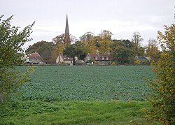
 St James's Church, Greenstead Green | |
| Location | |
| Grid reference: | TL822280 |
| Location: | 51°55’16"N, 0°38’56"E |
| Data | |
| Postcode: | CO9 |
| Local Government | |
| Council: | Braintree |
Greenstead Green is a village in Essex, near Halstead. The Bourne Brook running through the village curves round to join the River Colne a mile and a half north-eats of the village.
Other nearby villages include Burton's Green, Earls Colne, Plaistow Green and Tumbler's Green.
References
This Essex article is a stub: help to improve Wikishire by building it up.