Clackmannan: Difference between revisions
Jump to navigation
Jump to search
Created page with '{{Infobox town | name=Clackmannan | county=Clackmannanshire | gaelic=Clach Mhanainn | picture=Clackmannan.jpg | LG district=Clackmannanshire | constituency=Ochil and South Perths…' |
No edit summary |
||
| Line 3: | Line 3: | ||
| county=Clackmannanshire | | county=Clackmannanshire | ||
| gaelic=Clach Mhanainn | | gaelic=Clach Mhanainn | ||
| latitude=56.17 | |||
| longitude=-3.75 | |||
| picture=Clackmannan.jpg | | picture=Clackmannan.jpg | ||
| LG district=Clackmannanshire | | LG district=Clackmannanshire | ||
| constituency=Ochil and South Perthshire | | constituency=Ochil and South Perthshire | ||
}} | }} | ||
'''Clackmannan''' is a small town, which is nevertheless the [[county town]] of [[Clackmannanshire]]. | '''Clackmannan''' is a small town, which is nevertheless the [[county town]] of [[Clackmannanshire]]. | ||
Latest revision as of 09:38, 2 September 2010
| Clackmannan Gaelic: Clach Mhanainn | |
| Clackmannanshire | |
|---|---|

| |
| Location | |
| Location: | 56°10’12"N, 3°45’0"W |
| Data | |
| Local Government | |
| Council: | Clackmannanshire |
| Parliamentary constituency: |
Ochil and South Perthshire |
Clackmannan is a small town, which is nevertheless the county town of Clackmannanshire.
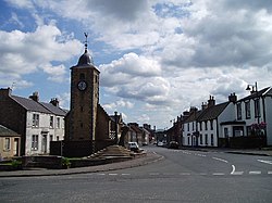
The name of the town is from the Gaelic for "Stone of Mannan", a pre-Christian monument which can be seen in the town square, beside the 16th century tolbooth tower.
During the 12th century, the area formed part of the lands controlled by the abbots of Cambuskenneth. Later it became associated with the House of Bruce. During the 14th century they built a strategic tower-house, which survives to this day above the town (looked after by Historic Scotland and which can only be viewed from the outside due to subsidence).