Faygate: Difference between revisions
Jump to navigation
Jump to search
Created page with "{{Infobox town |name=Faygate |county=Sussex |picture=Faygate - geograph.org.uk - 2906521.jpg |picture caption= |os grid ref=TQ218342 |latitude=51.09448 |longitude=-0.26189 |p..." |
No edit summary |
||
| Line 18: | Line 18: | ||
The village of Faygate is directly north west of [[Colgate, Sussex|Colgate]], across the A264 road and west of [[Kilnwood Vale]]. Other nearby settlements include [[Lambs Green]], [[Rusper]] and [[Pease Pottage]]. | The village of Faygate is directly north west of [[Colgate, Sussex|Colgate]], across the A264 road and west of [[Kilnwood Vale]]. Other nearby settlements include [[Lambs Green]], [[Rusper]] and [[Pease Pottage]]. | ||
The name 'Faygate' was first recorded in 1614.<ref> | The name 'Faygate' was first recorded in 1614.<ref>[https://www.british-history.ac.uk/vch/sussex/vol6/pt3/pp109-112 Rusper]: Victoria County History of Sussex</ref> | ||
==Outside links== | ==Outside links== | ||
Latest revision as of 19:09, 15 January 2023
| Faygate | |
| Sussex | |
|---|---|

| |
| Location | |
| Grid reference: | TQ218342 |
| Location: | 51°5’40"N, 0°15’43"W |
| Data | |
| Post town: | Horsham |
| Postcode: | RH12 4 |
| Dialling code: | 01293 |
| Local Government | |
| Council: | Horsham |
| Parliamentary constituency: |
Horsham |
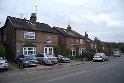
Faygate is a village in Sussex, on the A264 road three miles south-west of Crawley. It has a railway station on the Arun Valley Line with trains connecting to London and Portsmouth. The village is in the green belt between Crawley and Horsham.
The village of Faygate is directly north west of Colgate, across the A264 road and west of Kilnwood Vale. Other nearby settlements include Lambs Green, Rusper and Pease Pottage.
The name 'Faygate' was first recorded in 1614.[1]
Outside links
| ("Wikimedia Commons" has material about Faygate) |
