Foel Grach: Difference between revisions
Jump to navigation
Jump to search
Created page with '{{Infobox hill |name=Foel Grach |county=Caernarfonshire |range=Snowdonia |picture=Grach1.jpg |picture caption=Foel Grach from Carnedd Gwenllian |os grid ref=SH689659 |height=3,20…' |
No edit summary |
||
| Line 14: | Line 14: | ||
Foel Grach is on a broad ridge extending northwards from [[Carnedd Llewelyn]] to [[Carnedd Gwenllian]] and [[Foel-fras]]. An emergency refuge has been built beneath the summit. | Foel Grach is on a broad ridge extending northwards from [[Carnedd Llewelyn]] to [[Carnedd Gwenllian]] and [[Foel-fras]]. An emergency refuge has been built beneath the summit. | ||
Compared to the surrounding mountains much deeper snow takes place due to its rather broad summit and high grassy slopes. On clear days the [[Isle of Man]] and even the [[Mourne Mountains]] in [[Ulster]] can be seen Northwards from the summit. <ref>Nuttall, John & Anne (1999). The Mountains of England & Wales - Volume 1: Wales (2nd edition ed.). Milnthorpe | Compared to the surrounding mountains much deeper snow takes place due to its rather broad summit and high grassy slopes. On clear days the [[Isle of Man]] and even the [[Mourne Mountains]] in [[Ulster]] can be seen Northwards from the summit. <ref>Nuttall, John & Anne (1999). The Mountains of England & Wales - Volume 1: Wales (2nd edition ed.). Milnthorpe: Cicerone. ISBN 1-85284-304-7.</ref> | ||
==References== | ==References== | ||
Revision as of 20:16, 11 November 2014
| Foel Grach | |||
| Caernarfonshire | |||
|---|---|---|---|
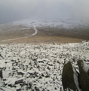
 Foel Grach from Carnedd Gwenllian | |||
| Range: | Snowdonia | ||
| Summit: | 3,202 feet SH689659 | ||
Foel Grach is a mountain in the Carneddau range of Snowdonia, in Caernarfonshire. It is the eighth highest summit in Snowdonia and is walked as part of the traverse of the Welsh 3000s.
The name "Foel Grach" means "scabby hill".
Foel Grach is on a broad ridge extending northwards from Carnedd Llewelyn to Carnedd Gwenllian and Foel-fras. An emergency refuge has been built beneath the summit.
Compared to the surrounding mountains much deeper snow takes place due to its rather broad summit and high grassy slopes. On clear days the Isle of Man and even the Mourne Mountains in Ulster can be seen Northwards from the summit. [1]
References
- ↑ Nuttall, John & Anne (1999). The Mountains of England & Wales - Volume 1: Wales (2nd edition ed.). Milnthorpe: Cicerone. ISBN 1-85284-304-7.