Puttenham, Hertfordshire: Difference between revisions
Jump to navigation
Jump to search
Created page with '{{Infobox town |name=Puttenham |county=Hertfordshire |picture=Puttenham - Church of Our Lady - geograph.org.uk - 606853.jpg |picture caption=Church of St Mary, Puttenham |os grid…' |
mNo edit summary |
||
| Line 2: | Line 2: | ||
|name=Puttenham | |name=Puttenham | ||
|county=Hertfordshire | |county=Hertfordshire | ||
|picture=Puttenham - Church of | |picture=Puttenham - Church of St Mary - geograph.org.uk - 606853.jpg | ||
|picture caption=Church of St Mary, Puttenham | |picture caption=Church of St Mary, Puttenham | ||
|os grid ref=SP888146 | |os grid ref=SP888146 | ||
Revision as of 22:39, 5 June 2012
| Puttenham | |
| Hertfordshire | |
|---|---|
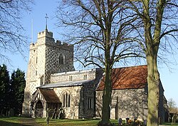
 Church of St Mary, Puttenham | |
| Location | |
| Grid reference: | SP888146 |
| Location: | 51°49’23"N, -0°42’47"W |
| Data | |
| Post town: | Tring |
| Postcode: | HP23 |
| Dialling code: | 01296 |
| Local Government | |
| Council: | Dacorum |
| Parliamentary constituency: |
South West Hertfordshire |
Puttenham is a small village in north-western Hertfordshire, within the Tring Salient.
It was recorded as 'Puteham' in the Domesday Book of 1086. [1]
Puttenham is one of the 51 Thankful Villages in England and Wales; villages which suffered no fatalities during the Great War of 1914 to 1918.
Outside links
| ("Wikimedia Commons" has material about Puttenham, Hertfordshire) |
