Nordenskjöld Coast: Difference between revisions
Jump to navigation
Jump to search
Created page with "right|thumb|230px|Location of the Nordenskjöld Coast {{territory|British Antarctic Territory}} The '''Nordenskjöld Coast''' is that po..." |
No edit summary |
||
| Line 14: | Line 14: | ||
{{DEFAULTSORT:Nordenskjold Coast}} | {{DEFAULTSORT:Nordenskjold Coast}} | ||
{{Catself}} | |||
[[Category:Coasts of Graham Land]] | [[Category:Coasts of Graham Land]] | ||
Revision as of 12:39, 13 July 2020

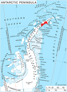
The Nordenskjöld Coast is that portion of the east coast of Graham Land in the British Antarctic Territory between Cape Longing and Cape Fairweather.
The name was proposed in 1909 by Edwin Swift Balch, for Otto Nordenskiöld, the Swedish geographer and leader of the Swedish Antarctic Expedition, 1901–04, who explored this coast in 1902 on his ship Antarctic.
The area was later explored by Lincoln Ellsworth.
Location
- Location map: 64°47’52"S, 59°9’31"W
References
- Gazetteer and Map of The British Antarctic Territory: Nordenskjöld Coast