Benbrack, County Cavan: Difference between revisions
Jump to navigation
Jump to search
No edit summary |
No edit summary |
||
| Line 4: | Line 4: | ||
|range=Iron Mountains | |range=Iron Mountains | ||
|picture=Benbrack, County Cavan, from Bellavally Upper townland - geograph-3597153.jpg | |picture=Benbrack, County Cavan, from Bellavally Upper townland - geograph-3597153.jpg | ||
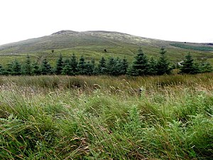
|picture=Benbrack, County Cavan | |picture caption=Benbrack, County Cavan | ||
|os grid ref=H10122160 | |os grid ref=H10122160 | ||
|latitude=54.143466 | |latitude=54.143466 | ||
Latest revision as of 18:40, 9 February 2018
| Benbrack | |||
| County Cavan | |||
|---|---|---|---|
 Benbrack, County Cavan | |||
| Range: | Iron Mountains | ||
| Summit: | 1,647 feet H10122160 54°8’36"N, 7°50’45"W | ||
Benbrack is a hill of 1,647 feet in the Iron Mountains of County Cavan. Its name is from the Irish An Bhinn Bhreac, meaning 'The Speckled Peak'.
This sandstone mountain stands in the Breifne area of the county, which runs up to the British border, marked by the county's highest mountain, Cuilcagh (2,182 feet).
The summit area is a broad, flat plain of broken, boggy terrain and the actual summit point at 1,647 feet is barely distinguishable. The top does though give fine views, in fair weather of the Cuilcagh Mountains to the north and down to the Bellavally Gap.
The mountain has two notable subsidiary tops:
- Benback North East Top, 1627 feet, marked by a cairn at H113236
- Benbrack West Top, 1,519 at H066221