Belvoir: Difference between revisions
Jump to navigation
Jump to search
Created page with "{{infobox town |name=Belvoir |county=Leicester |latitude=52.89212 |longitude=-0.78315 |picture=Belvoir_Castle_-_geograph.org.uk_-_50333.jpg |picture caption=Belvoir Castle |po..." |
m Owain moved page Belvoir, Leicestershire to Belvoir |
(No difference)
| |
Latest revision as of 08:21, 24 October 2017
| Belvoir | |
| Leicestershire | |
|---|---|
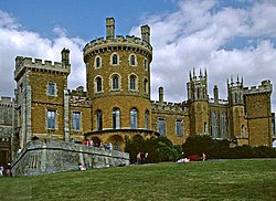
 Belvoir Castle | |
| Location | |
| Grid reference: | SK819334 |
| Location: | 52°53’32"N, -0°46’59"W |
| Data | |
| Population: | 263 (2011 (Including Knipton and Harston)) |
| Post town: | Grantham |
| Postcode: | NG32 |
| Dialling code: | 01476 |
| Local Government | |
| Council: | Melton |
| Parliamentary constituency: |
Rutland and Melton |
Belvoir is a village and civil parish in Leicestershire, on the county border with Lincolnshire. The nearest town is Grantham, eight miles east of the village.
The civil parish includes the villages of Belvoir, Knipton and Harston. Nearby places outside the parish are Woolsthorpe by Belvoir, Redmile, and Croxton Kerrial.
The village is the site of Belvoir Castle, which "stands on a prominent spur jutting northwards" into the Vale of Belvoir.[1]
Iron ore was formerly quarried in the parish and details can be found in the articles on Knipton and Harston. The quarries were near Harston, to the south of Knipton and between Belvoir and Knipton.
References
| ("Wikimedia Commons" has material about Belvoir) |
- ↑ Fox, Alan (1 April 2010). A Lost Frontier Revealed: Regional Separation in the East Midlands. Univ of Hertfordshire Press. p. 38. ISBN 978-1-907396-36-6. https://books.google.com/books?id=kqWVGljk1RMC&pg=PA38.

This Leicestershire article is a stub: help to improve Wikishire by building it up.
