Pencaer: Difference between revisions
Jump to navigation
Jump to search
No edit summary |
No edit summary |
||
| Line 1: | Line 1: | ||
{{county|Pembroke}} | |||
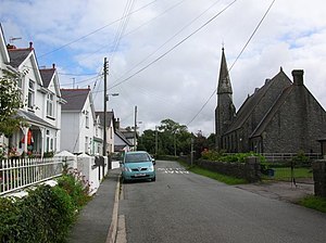
[[File:Llanwnda - geograph.org.uk - 1062786.jpg|thumb|Llanwnda village]] | [[File:Llanwnda - geograph.org.uk - 1062786.jpg|thumb|Llanwnda village]] | ||
'''Pencaer''' is a parish which covers an area of dispersed settlement to the west of [[Fishguard]] and [[Goodwick]] in [[Pembrokeshire]]. It comprises the village of [[Llanwnda, Pembrokeshire|Llanwnda]] and smaller settlements such as Tremarchog. | '''Pencaer''' is a parish which covers an area of dispersed settlement to the west of [[Fishguard]] and [[Goodwick]] in [[Pembrokeshire]]. It comprises the village of [[Llanwnda, Pembrokeshire|Llanwnda]] and smaller settlements such as Tremarchog. | ||
Revision as of 23:08, 20 November 2016

Pencaer is a parish which covers an area of dispersed settlement to the west of Fishguard and Goodwick in Pembrokeshire. It comprises the village of Llanwnda and smaller settlements such as Tremarchog.
Strumble Head lies within the parish.
References
- Location map: 52°-0’58"N, 5°-0’53"W