Arrochar: Difference between revisions
No edit summary |
No edit summary |
||
| Line 24: | Line 24: | ||
The village was a key target for Viking raiders who took their boats two miles overland to Tarbet to attack the unprotected inland settlements at Loch Lomond. | The village was a key target for Viking raiders who took their boats two miles overland to Tarbet to attack the unprotected inland settlements at Loch Lomond. | ||
At the western end of Arrochar, the Loin Water marks the border of [[Dunbartonshire]] with [[Argyllshire]], with the village almost contiguous with [[Succoth]] in the latter county. | |||
==Arrochar Torpedo Testing Facility== | ==Arrochar Torpedo Testing Facility== | ||
Latest revision as of 13:05, 11 October 2017
| Arrochar Gaelic: An t-Àrchar | |
| Dunbartonshire | |
|---|---|
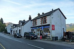
 The Village Shop, Arrochar | |
| Location | |
| Grid reference: | NN296038 |
| Location: | 56°11’46"N, 4°44’53"W |
| Data | |
| Post town: | Arrochar |
| Postcode: | G83 |
| Local Government | |
| Council: | Argyll and Bute |
| Parliamentary constituency: |
Argyll and Bute |
Arrochar is a village and parish in northern Dunbartonshire. The village lies near the head of Loch Long, with the parish extending right to the northern extent of the county, bordering the surrounding counties of Stirling, Perth and Argyll.
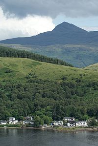
The village is overlooked by a noble range of mountains named the Arrochar Alps, and in particular by the distinctive rocky summit of the Cobbler, a mountain of nearly 3,000 feet. It enjoys good communications as it is at the junction of the A83 and A814 roads and is served by Arrochar and Tarbet railway station. In addition the A82 road runs through Tarbet two miles to the east.

For over five centuries this area, the feudal barony of Arrochar, was held by the chiefs of Clan MacFarlane and before them by their ancestors the barons of Arrochar.
The village was a key target for Viking raiders who took their boats two miles overland to Tarbet to attack the unprotected inland settlements at Loch Lomond.
At the western end of Arrochar, the Loin Water marks the border of Dunbartonshire with Argyllshire, with the village almost contiguous with Succoth in the latter county.
Arrochar Torpedo Testing Facility

There was for many years a torpedo testing facility on Loch Long, for which the base was by Arrochar. It was decommissioned in 1980 and is currently part demolished. Demolition has been stalled since a fire on the site in June 2007.
Unarmed torpedoes were fired up Loch Long from tubes at the front of the facility. A boat stood by to recover the torpedoes where they were returned for analysis. The now roofless shed to the left and the main part of the building have tracks where torpedoes were stored and worked on. Hoists on the first floor lowered the torpedoes into the tubes.
The control room at the top looking straight down the loch housed a camera. Behind the control room, above the loading shed, is office accommodation. The rest of the facility included housing and workshops but these have been sold off.
Outside links
| ("Wikimedia Commons" has material about Arrochar) |
- The International Clan MacFarlane Society, Inc.
- Arrochar local community
- Arrochar, Tarbet and Ardlui History
- Arrochar and Tarbet - directory
- Arrochar and Tarbet Community Development Trust
- Arrochar & Tarbet information
