Template:FP-Dunnet Head: Difference between revisions
Jump to navigation
Jump to search
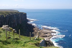
Created page with "{{#switch:{{{1}}} |pic=Dunnet Head cliffs - geograph.org.uk - 1387084.jpg |cap=Cliffs at Dunnet Head, Caithness |text='''Dunnet Head''' is a headland in Caithness, whose t..." |
No edit summary |
||
| Line 6: | Line 6: | ||
The traditional measure of Great Britain is 'Land's End to John o' Groats', but Dunnet Head, eleven miles east of John o' Groats, easily surpasses it for latitude. | The traditional measure of Great Britain is 'Land's End to John o' Groats', but Dunnet Head, eleven miles east of John o' Groats, easily surpasses it for latitude. | ||
The peninsula is east of the burgh of Thurso, and on a clear day, it affords excellent views of the islands Stroma to the east, and to Hoy and to [[Mainland, Orkney|Orkney Mainland]], nine miles away to the north, across the Pentland Firth.}}<noinclude> | The peninsula is east of the burgh of Thurso, and on a clear day, it affords excellent views of the islands Stroma to the east, and to Hoy and to [[Mainland, Orkney|Orkney Mainland]], nine miles away to the north, across the Pentland Firth.}}<noinclude>{{FP data}} | ||
Latest revision as of 18:51, 6 May 2021
 |
Dunnet HeadDunnet Head is a headland in Caithness, whose tip, Easter Head, is the most northerly point of the mainland of Great Britain. Dunnet Head, projecting into the Atlantic Ocean, shelters Dunnet Bay and marks the western limit of the Pentland Firth on the firth's southern, or Caithness, side. The traditional measure of Great Britain is 'Land's End to John o' Groats', but Dunnet Head, eleven miles east of John o' Groats, easily surpasses it for latitude. The peninsula is east of the burgh of Thurso, and on a clear day, it affords excellent views of the islands Stroma to the east, and to Hoy and to Orkney Mainland, nine miles away to the north, across the Pentland Firth. (Read more) |